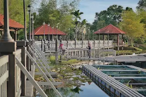
Featured Reviews


Frequently mentioned in reviews: Bukit (12) hiking (11) track (8) peak (7) view (7) hike (6) climb (6) Good (6) untuk (6) Parking (6)
Reviews are sorted by relevance, prioritizing the most helpful and insightful feedback at the top for easier reference.
  • 4/5 Azman A. 1 year ago on Google
    Bukit Payung - Locality at Kampung Kangkar Merlimau, Parit Sulong in Batu Pahat District, Johore Darul Takzim, Malaysia. It's a popular place for hiking, mtb, motocross and it open year-round. A challenging route with rocky and sandy trails. Accessible start point from Bukit Berdiri and Bukit Botak entrance/trailhead. You can explore and enjoy some solitude during quite a few hill no more half a day - 'hills hoping'. The distance is about 10.3 km and it takes an average of 3-4 hours ++ to compete. Bukit Payung was connected to four other hills at the same area with Bukit Berdiri, Bukit Botak, Bukit Alam and Bukit Bandkuit. When reached at the hilltop the pathway/trail from one peak to other peak is easy where all trails are well marked that's mainly used by locals. πŸ™„ πŸ€—
    8 people found this review helpful πŸ‘

  • 5/5 Desmond 1 year ago on Google
    entrance is just beside a mly house, easy to find:) Overall it is suitable for beginner but the road mark is not that significant, I cant find the air terjun though πŸ˜‚
    6 people found this review helpful πŸ‘

  • 5/5 Schuan K. 6 years ago on Google
    Great place for hiking. You can hike to bukit payung peak, then follow the white paper marking to water fall , then connect to bukit berdiri .
    5 people found this review helpful πŸ‘

  • 5/5 Ace Andy M. 4 years ago on Google
    Steep climb. 1.5hrs for beginners like us. Usually they say 1hr to the top. Amazing views. One of the best place to hike for beginners. As the steep climb need some upper body strength and balance on the loose soil.
    3 people found this review helpful πŸ‘

  • 5/5 roshaidi abdul t. 5 years ago on Google
    (Translated by Google) let's try to climb ... no loss of beautiful views (Original) jom cuba daki...tak rugi permandangan cantik
    2 people found this review helpful πŸ‘

  • 5/5 Encik G. 3 years ago on Google
    Nice
    1 person found this review helpful πŸ‘

  • 5/5 Sewari K. 4 years ago on Google
    Good hiking
    1 person found this review helpful πŸ‘

  • 4/5 Richard M. 5 years ago on Google
    Challenging mountain to hike at Parit Sulong. A few routes that u can explore but be careful not to be lost as we got lost hiking to Bukit Botak route.
    1 person found this review helpful πŸ‘

  • 4/5 Harris I. 2 years ago on Google
    Great tracks!
    1 person found this review helpful πŸ‘

  • 3/5 Bidi aka M. 6 years ago on Google
    Easy ascending trail with beautiful scenery.
    1 person found this review helpful πŸ‘

  • 5/5 RAJ B. 5 years ago on Google
    Lovely nature hike and loved every moment there
    1 person found this review helpful πŸ‘

  • 5/5 Khirul Faizi s. 5 years ago on Google
    TerbaikkπŸ‘πŸ‘

  • 5/5 Uncle N. 4 years ago on Google
    (Translated by Google) The best place for recreation, you can choose five tops here. It's best to have friends (Original) Tempat yang best untuk rekreasi, boleh pilih lima puncak yang ada kat sini. Memang best lah kalau bawak sekali kawan2

  • 2/5 crongte z. 4 years ago on Google
    (Translated by Google) Not bad (Original) Boleh tahan

  • 5/5 Jenny T. 8 months ago on Google
    Trans payung 3 peak hike. What an experience and great hike. Highly recommended

  • 5/5 Tan Chin H. 5 years ago on Google
    The best hiking place .

  • 5/5 jafri m. 5 years ago on Google
    (Translated by Google) Bravely to climb, fun only when it comes to the summit (Original) Kena berani untuk mendaki, keseronokan hanya bila sampai ke puncak

  • 4/5 Nur S. 5 years ago on Google
    (Translated by Google) Parking for rent car rm5. Parking bas pay rm100. Parking motor free je. Sign up before you go up. (Original) Parking untuk kereta kena bayar rm5. Parking bas bayar rm100. Parking motor free je. Daftar dulu sebelum naik.

  • 5/5 Yeo C. 10 months ago on Google
    adventurous. challenging

  • 5/5 Muhammad Hafiz Bin H. 5 years ago on Google
    Nice place to go

  • 5/5 Maisarah S. 1 year ago on Google
    Beginner to moderate, very nice view at the peak

  • 5/5 Cik n. 5 years ago on Google
    Best

  • 5/5 Nur H. 5 years ago on Google
    Adventuring.

  • 2/5 Kang E. 5 years ago on Google
    (Translated by Google) Pretty (Original) Đẹp

  • 5/5 Ryu D. 5 years ago on Google
    best place for hiking

  • 4/5 anniee T. 4 years ago on Google
    (Translated by Google) A nice place Just one hour up and down (Original) A nice place δΈŠδΈ‹εͺιœ€δΈ€δΈͺ小既

  • 5/5 Yen W. 2 years ago on Google
    The view at the peek is amazing, worth the effort, especially in the morning when there's morning mist. Enjoyed the cool breeze. Climbing up is quite easy, took us around 50mins with kids. But coming down was a challenge for us.. We kinda "crawled" down the Bukit.

  • 5/5 mpkk18ps k. 1 year ago on Google
    Nice

  • 5/5 Manuel M. 1 year ago on Google
    Good place to do training for major hikes.

  • 5/5 Cempaka P. 4 years ago on Google
    Hiking activities.. nice view...

  • 5/5 Mehmet W. 5 years ago on Google
    Good place for hiking especially for beginner.

  • 2/5 Ku N. 4 years ago on Google
    This hills has great track and view at the top. The track is very tricky because landslide happen here before,so the track has chance littel.i only rated 2 star because of the safety of the track. Rope along the track is very unsuitable for the climber and hikers...

  • 5/5 Irfan Z. 3 years ago on Google
    Let's save this hiking place from becoming a landfill.

  • 5/5 norliah s. 4 years ago on Google
    A rather interesting place to bring 12-20 yo kids to exercise . Can take pictures or photographs with the environment for free. However, be careful during raining coz it might be slippery

  • 5/5 Keerrtanah B. 4 years ago on Google
    Good and friendly people, warm welcome and good hospitality. Great place for vacation.

  • 5/5 NFR 9. 3 years ago on Google
    (Translated by Google) Alhamdulillah ya Syakur ya Aziz ya Qowiy ya Matin .. -newbie- (Original) Alhamdulillah ya Syakur ya Aziz ya Qowiy ya Matin.. -newbie-

  • 5/5 Yuhasnor Y. 3 years ago on Google
    (Translated by Google) Not high, but steep, and sandy. (Original) Tak tinggi, tapi curam, dan berpasir.

  • 5/5 zulhilmi k. 3 years ago on Google
    (Translated by Google) Paid car parking area below. It is safe. From there go up the trail next door. Can ask the parking attendant. To climb to the peak I took 1 hour. The road is paved to the top, you can only bring the boy if you can already go to school. Because a lot of traffic is a bit steep. (Original) Kawasan parking kereta yang berbayar dibawah. Memang selamat. Dari situ naik je trail disebelah. Boleh tanya org jaga parking. Untuk naik ke peak saya mengambil masa 1jam. Jalan bertali untuk ke atas, boleh bawa budak cumanya kalau boleh yg dah sekolah lah. Sebab banyak laluam agak curam.

  • 5/5 William k. 3 years ago on Google
    (Translated by Google) Good place for climbing (Original) ηˆ¬ε±±ηš„ε₯½εŽ»ε€„

  • 5/5 Muhammad Diyaudin F. 3 years ago on Google
    (Translated by Google) Insyaallah repeat lg (Original) Insyaallah repeat lg

  • 5/5 Awie A. 3 years ago on Google
    (Translated by Google) View them (Original) View lawo

  • 5/5 Ummu A. 3 years ago on Google
    (Translated by Google) the track is rather sandy and rocky. Very beautiful view (Original) trek agak berpasir dan berbatu. View sangat cantik

  • 4/5 ai lynn Z. 4 years ago on Google
    (Translated by Google) A relaxing track, perfect for relaxing with little ones. (Original) Trek yg santai, sesuai untuk beriadah bersama anak-anak kecil.

  • 5/5 Mijot Anak Hj. Othman Bin Hj. S. 4 years ago on Google
    Love the view

  • 4/5 mohd shahidan e. 4 years ago on Google
    (Translated by Google) challenging (Original) Mencabar

  • 5/5 Tan Chin Fu - P. 4 years ago on Google
    Nice hiking place πŸ‘

  • 5/5 Nur A. 4 years ago on Google
    (Translated by Google) Hiking is really challenging (Original) Hiking yng sangat mencabar❀ really love itπŸ‘

  • 5/5 MEER 4 years ago on Google
    (Translated by Google) Elevation: 848 feet @ 258 meters above sea level. Time to climb Bukit Umbrella only: About 45 minutes depending on their stamina. View from the top of the umbrella hills: Batu Pahat Town Area, Mount Banang, Straits of Malacca, around Parit Sulong and Yong Peng. (Original) Ketinggian : 848 kaki @ 258 meter diatas paras laut. Masa diambil untuk mendaki Bukit Payung sahaja : Lebih kurang 45 minit bergantung pada stamina masing-masing. Pemandang dari puncak bukit payung : Kawasan Bandar Batu Pahat, Gunung Banang, Selat Melaka, sekitar Parit Sulong dan Yong Peng.

  • 5/5 mr b. 4 years ago on Google
    Overall track easy to moderate

  • 3/5 alias y. 4 years ago on Google
    Good for beginners

  • 5/5 Nik I. 3 years ago on Google
    Great place for hiking especially for beginners . Only take one hour or 2 hour. Amazing view there

  • 5/5 Tang Kee F. 4 years ago on Google
    Nice hiking place

  • 4/5 Mohamad Faizal Abu B. 8 months ago on Google β€’ 24 reviews
    Best.. Pacak without discount!!


Open on Google Maps

Trends


Last updated:

Similar Tourist attractions nearby

Taman Botani Batu Pahat Johor image
1
Taman Botani Batu Pahat Johor
Botanical garden
πŸ‘ Located about 30mins each from batu pahat and yong peng city centre. Beautiful place. It definitely can be way better with better maintenance. This Taman is surrounded by 2 lakes in which one is yellow thanks to all the plants covering it and another one was clear.
4.10 (287 reviews)
Last updated:
()