4/5 Wael C. 3 years ago on Google
(Translated
by
Google)
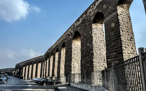
673:
The
wall
of
the
course
of
El-Ayoun,
Ancient
Egypt,
Fustat
Trace
number:
78
Location:
There
is
a
wall
of
El-Ayoun
stream
in
ancient
Egypt,
and
it
starts
from
the
mouth
of
the
Gulf
to
the
Bab
al-Qarafa
Gate
in
Mrs.
Aisha.
Originator:
Creation:
Qansouh
Al-Ghoury
Date
created
:
Building:
912-914
AH
/
1506-1580
AD
Stream
History:
During
his
wisdom,
Sultan
al-Ghuri
set
up
for
her
a
water
outlet
with
six
drivers
near
the
Mosque
of
Sayyida
Aisha.
Nothing
remains
of
the
arches
that
Salah
al-Din
built
partially
except
for
a
few
remnants
at
the
beginning
of
the
course
from
the
side
of
the
castle
facing
the
Mosque
of
Sayyida
Aisha.
He
had
taken
advantage
of
the
Cairo
wall,
which
he
had
made,
and
made
the
course
of
the
water
a
high.
As
for
the
current
arches,
Sultan
Al-Nasir
Muhammad
bin
Qalawun
rebuilt
them
completely
in
two
stages.
During
them,
four
drivers
were
established
on
the
Nile
at
the
mouth
of
the
Gulf
to
raise
water
from
a
small
bay
at
the
observation
wall,
which
is
known
today
as
Istbal
Antar,
towards
the
Athar
al-Nabi
Mosque,
which
is
the
building
that
Muhammad
Ali
Pasha
transformed
during
his
wisdom
into
his
burial
place
for
weapons.
The
mouth
of
the
Gulf
stream:
Al-Nasir
Muhammad
ibn
Qalawun
established
the
stream
of
Ayoun
Fum
al-Khaleej
to
deliver
the
waters
of
the
Nile
to
the
mountain
castle,
and
it
remains
to
this
day.
For
when
he
wanted
the
castle
to
supply
more
water,
he
ordered
a
well
to
be
dug
on
the
coast
of
the
Nile
and
built
over
it
barrages
connected
to
the
barrages
(the
wall
of
Salah
al-Din)
where
there
is
another
stream
of
water
from
two
wells:
the
well
of
the
wall
of
Salah
al-Din,
and
the
well
of
the
Qanater
And
it
becomes
one
water
that
flows
into
the
castle.
It
was
around
the
year
1312
AD,
but
he
died
before
he
could
complete
this
work.
And
the
French
campaign,
where
its
men
blocked
most
of
the
arches
and
used
it
as
a
wall
for
defense.
Over
time,
he
neglected
his
command
and
people
constructed
buildings
adjacent
to
Al-Ayyun,
its
north
and
south,
until
he
began
to
repair
them
before
the
revolution.
.
The
length
of
the
existing
stream,
which
extends
from
the
mouth
of
the
Gulf
to
the
Bab
al-Sayyida
Aisha
(Qaitbay),
is
about
three
kilometers
long,
and
the
Corniche
Road
now
separates
the
head
of
the
stream
from
the
Nile.
Architectural
Description:
The
architecture
of
these
arches
consists
of
a
huge
wall
that
extends
from
the
mouth
of
the
Gulf
to
Sayyida
Aisha
Square,
after
it
was
old
to
the
castle.
,
In
the
era
of
the
Al-Ghoury
Sultan,
another
water
intake
was
established
for
these
aqueducts
with
six
drivers
near
the
Lady
Nafsiah
to
strengthen
the
current
of
water
that
reached
her
from
the
wells
of
the
castle.
The
Mawajat
Tower
is
the
building
in
which
there
are
6
drivers,
and
that
is
why
it
was
called
by
the
name
«Seven
Drivers»,
considering
that
the
seventh
wheeler
is
located
behind
the
fence
and
not
with
the
six
above,
even
if
the
seventh
wheelwheel
was
gone
Watering
contracts,
which
is
the
same
wall
that
is
divided
into
several
arches
and
that
carries
the
water
channel
on
the
top
and
is
called
the
stream
of
eyes.
Dearest
victory
»,
The
arches
of
the
wall
of
Salah
al-Din
al-Ayyubi
are
related
to
it
at
Sabil
al-Wasiya
and
even
to
the
castle.
This
stream
was
repaired
in
the
year
812
AH
-
1408
AH
by
Emir
Yalbugha
al-Salmi,
then
Sultan
al-Ghuri
rebuilt
it
in
the
year
911
AH
-
1505
AH.
And
during
the
Ottoman
era,
Abdo
Pasha
repaired
some
parts
of
it
in
the
year
1140
AH
-
1728
AH.
Sources
:
1:
Abdel-Rahman
Zaki,
Encyclopedia
of
Cairo
City
in
a
Thousand
Years,
Cairo:
The
Anglo-Egyptian
Library,
1987,
p.
253.
2:
Photo
"1"
Lens:
Professor.
Ahmed
Rmeih.
Photographer
of
the
Ministry
of
Tourism
and
Antiquities.
Egyptian.
Egypt
(Original)
673:سور
مجرى
العيون
.مصر
القديمة
.الفسطاط
رقم
الاثر
:
78
المـوقع
:
يوجد
سور
مجرى
العيون
فى
منطقة
مصر
القديمة
ويبدأ
من
فم
الخليج
إلى
باب
القرافة
بالسيدة
عائشة.
المنشئ
:
الانشاء
:
قنصوة
الغورى
تاريخ
الانشاء
:
البناء:
912
ـ
914
هـ
/
1506
ـ
1580
م
تاريخ
المجرى
:
أقام
لها
السلطان
الغوري
خلال
حكمة
مأخذا
للمياه
به
ست
سواق
بالقرب
من
مسجد
السيدة
عائشة.
ولم
يبق
من
القناطر
التي
أنشأها
صلاح
الدين
شئيا
غير
بقايا
قليلة
في
بداية
المجرى
من
ناحية
القلعة
مواجهة
لمسجد
السيدة
عائشة،
كان
قد
استغل
فيها
سور
القاهرة
الذي
عمله
وجعل
مجرى
المياه
علوه
أما
القناطر
الحالية
فقد
أعاد
السلطان
الناصر
محمد
بن
قلاوون
بناءها
كاملة
على
مرحلتين،
وقد
أنشأ
خلالهما
أربع
سواق
على
النيل
بفم
الخليج
لرفع
الماء
من
خليج
صغير
عند
حائط
الرصد
الذي
يعرف
اليوم
باسم
اسطبل
عنتر
تجاه
مسجد
أثر
النبى،
وهو
المبنى
الذي
حوله
محمد
على
باشا
أثناء
حكمة
إلى
جبخانه
للسلاح،
مجري
عيون
فم
الخليج
:
أقام
الناصر
محمد
بن
قلاوون
مجرى
عيون
فم
الخليج
لتوصيل
مياه
النيل
إلى
قلعة
الجبل
و
مازالت
باقية
إلى
اليوم
،
فإنه
لما
أراد
أن
يمد
القلعة
مزيد
من
الماء
أمر
بحفر
بئر
عند
ساحل
النيل
و
أقام
عليه
قناطر
تتصل
بالقناطر
(سور
صلاح
الدين)
حيث
توجد
مجرى
أخرى
للماء
من
بئرين
:
بئر
سور
صلاح
الدين
،
وبئر
القناطر
فيصير
ماءً
واحداً
يجري
إلى
القلعة
.
كان
ذلك
في
حوالي
عام
1312م
،
لكنه
مات
قبل
أن
يكمل
هذا
العمل
.
و
الحملة
الفرنسية
حيث
سد
رجالها
معظم
عقود
القناطر
و
استخدمته
سوراً
للدفاع
.
و
على
مر
الزمن
أهمل
أمره
و
شيد
الناس
المباني
ملاصقة
للعيون
،
شمالها
و
جنوبها
حتى
شرع
في
إصلاحها
قبيل
الثورة
فأدرك
رجالها
أهمية
شق
طريق
يصل
ما
بين
القلعة
و
شارع
قصر
العيني
،
فنفذ
المشروع
في
أشهر
قلائل
بعد
ما
أزيلت
جميع
المباني
الخربة
التي
اعترضت
الطريق
.
يبلغ
طول
المجرى
الموجود
الآن
و
الذي
يمتد
من
فم
الخليج
إلى
باب
السيدة
عائشة
(قايتباي)
حوالي
ثلاث
كيلو
مترات
،
و
يفصل
الآن
طريق
الكورنيش
بين
رأس
المجرى
و
بين
النيل
.
الوصف
المعمارى
:
تتكون
عمارة
هذه
القناطر
من
سور
ضخم
يمتد
من
فم
الخليج
حتى
ميدان
السيدة
عائشة
بعدما
كان
قديما
حتى
القلعة
وقد
بنى
ها
السور
من
الحجر
النحيت
وتجرى
عليه
مجراه
فوق
مجموعة
ضخمنه
من
القناطر
(العقود)
المدببة
كانت
تنتهى
بصب
مياها
في
مجموعة
من
الآبار
الضخمة
داخل
القلعة،
وفى
عصر
السلطان
الغورى
أقيم
لهذه
القناطر
مأخذ
مياه
آخر
به
ست
سواق
بالقرب
من
السيدة
نفسية
لتقوية
تيار
المياه
الواصلة
منها
إلى
آبار
القلعة.
برج
المآخذ
هو
المبنى
الذى
توجد
به
6
سواقى،
ولذلك
كان
يطلق
عليه
من
قبل
اسم
«السبع
سواقى»
على
اعتبار
أن
الساقية
السابعة
توجد
خلف
السور
وليست
مع
الست
المتواجدة
أعلاه،
وإن
كانت
الساقية
السابعة
و
اندثرت
عقود
السقاية
و
هو
السور
نفسه
المقسم
إلى
عدة
عقود
والحامل
للقناة
المائية
فى
أعلاه
والمسماة
بالمجرى
«مجرى
العيون»
وهي
جنزيرية
منحنية
غير
مستقيمة
تتصل
بعضها
ببعض
وعلي
العقود
«رنكات»
-
أختام
-
كتب
عليها
عبارة:
«عز
لمولانا
السلطان
الملك
الأشرف
أبوالنصر
قانصوه
الغورى
أعز
نصره»،
عقود
سور
صلاح
الدين
الأيوبى
يتصل
به
عند
سبيل
الوسية
وحتى
القلعة.
أصلح
هذا
المجرى
سنة
812
هـ
-
1408
هـ
بواسطة
الأمير
يلبغا
السالمي
،
ثم
أعاد
بناءها
السلطان
الغوري
سنة
911
هـ
-
1505
هـ
.
و
في
العهد
العثماني
أصلح
عبده
باشا
بعض
أجزائه
سنة
1140
هـ
-
1728
هـ
.
المصادر
:
1:
عبد
الرحمن
زكي
،
موسوعة
مدينة
القاهرة
في
ألف
عام
،
القاهرة
:
مكتبة
الأنجلو
المصرية
،
1987
،
ص253
.
2:
الصور
"1"
عدسة
:
أستاذ
.
أحمد
رميح
.
مصور
وزارة
السياحة
و
الاثار
.
مصري
.
مصر
1 person found this review helpful 👍