Featured Reviews


Reviews are sorted by relevance, prioritizing the most helpful and insightful feedback at the top for easier reference.
  • 5/5 comautoo 5 years ago on Google
    Magnífico lugar para conectarse con la naturaleza al mismo tiempo que haces un gran esfuerzo para subir a la cima y disfrutar de tanta historia al recorrer el gran tetzacualco de largas y altas paredes que forman un gran templo y adoratorio donde nuestro ansestros se conectaban con sus divinidades
    6 people found this review helpful 👍

  • 5/5 Ernesto D. 4 years ago on Google
    Hiked to summit of Mt. Tlaloc beginning at Centro Ecoturistico Canoas Altas during October. It is approximately 2.8 miles from there and took us just under 3 hours and 2 hours on the return. Temperature ranged between 45 F to 60 F. Elevation at the summit is approximately 13,540 feet according to the phone app. Forgot to take elevation reading at the start so I’m unsure what the elevation gain was. It was a a difficult climb since there aren’t any switch backs and the trail is essentially a direct path to the summit. Excellent time of year for this as the climate is cool. Was able to get by with 1.5 L of water. There are no services, restrooms nor stores in between these two points. Cell phone service trickled in at one spot about 40 minutes prior to reaching the summit otherwise it is nonexistent. Excellent scenery on the way as you pass a point where the Popo is visible and makes a great background for a photo.
    5 people found this review helpful 👍

  • 5/5 Samara S. 1 year ago on Google
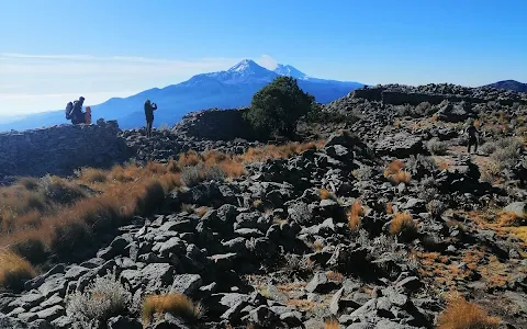
    Una subida muy retadora que parece no tener fin, pero la vista al llegar a la cima es increíble, puedes ver el volcán Popocatépetl a lo lejos, aunque parece estar muy cercano. En la cima también encontrarás un adoratorio y unas pequeñas ruinas. (Sigue el acueducto y te guiará al punto más alto). El acceso tiene un costo de $10 para personas con o sin bicicleta. En tu recorrido encontrarás el centro ecoturístico en el que hay una tiendita y puedes comprar víveres. La ruta y el terreno son aptos para acampar. Lo malo: Pasan autos y razers por el camino ancho y algunos ponen en riesgo a los caminantes/corredores/ciclistas al pasar muy rápido.
    3 people found this review helpful 👍

  • 5/5 Krishan N. 11 months ago on Google
    Ruda desde San Pablo Ixayoc, 7 horas, 6 de subida y 1 de bajada corriendo.
    2 people found this review helpful 👍

  • 5/5 CesarVid 2 years ago on Google
    (Translated by Google) Very nice place to do many things outdoors (Original) Muy bonito lugar para hacer muchas cosas al aire libre
    1 person found this review helpful 👍

  • 5/5 Miroslava L. 1 year ago on Google
    Un gran lugar para desconectar y sentir la naturaleza en todo su esplendor 😍⛰️
    1 person found this review helpful 👍

  • 5/5 Eber R. 5 years ago on Google
    Awesome!

  • 5/5 Fidel P. 5 years ago on Google
    Super!!!

  • 3/5 Gabino C. 2 years ago on Google
    Por San Pablo ixayoc te cobran el acceso, si vienes en vehiculo, desde bici $10.00 y de allí para arriba, y si vas por los caminos principales hay mucho polvo, lo bueno es que hay varios lugares para comprar cosas.

  • 4/5 JK J. 1 year ago on Google
    (Translated by Google) To enjoy the wonderful nature and a good walk to climb the highest shrine in Mexico discover its magic and charm (Original) Para disfrutar de la maravillosa naturaleza y una buena buena caminata para subir al adoratorio más alto de Mexico descubrir su magia y encanto

  • 5/5 Jenny M. 2 years ago on Google
    (Translated by Google) Super tired to climb, but if you get to camp you can enjoy the sunrise (Original) Super cansado para subir, pero si llegas a acampar podrás disfrutar el amanecer


Open on Google Maps

Trends


Last updated:

Similar Museums nearby

Last updated:
()