Featured Reviews


Reviews are sorted by relevance, prioritizing the most helpful and insightful feedback at the top for easier reference.
  • 5/5 Grecia Nina S. 4 years ago on Google
    5.030 msnm... la vista es bellísima!!! De los mejores lugares donde ir en Cochabamba, especialmente cuando hace frío y hay nieve, el trekking es fantástico 🏔🤩 el camino no está mal, toma aproximadamente 2 a 3 horas llegar en movilidad, pero se recomienda tomar las medidas necesarias tanto para el automóvil como para los posibles síntomas que puede causar la falta de oxígeno debido a la altura.
    12 people found this review helpful 👍

  • 5/5 Martin S. 2 years ago on Google
    Very recommandable! Normally you drive up to almost 4600 m. From there its just 2-3 hours to the top. But don't underestimate the hight and the thin air. I suggest taking Sorojchi pills before and during the hike (you get them in every pharmacy). The view from the top is just unbelievable and if you're lucky you can see the Illimani.
    4 people found this review helpful 👍

  • 5/5 Johans Marvin Taboada V. 7 years ago on Google
    A challenging trekking route with great sights.
    4 people found this review helpful 👍

  • 5/5 Matt T. 5 years ago on Google
    Incredible view
    4 people found this review helpful 👍

  • 5/5 Herman G. 4 years ago on Google
    It's only 1,500 feet from the lake/parking area to the top. But to reach peak of 16,500 (5030m) it's going to take all you got! I have a lot of respect for those who climb mountains after this peak. Come prepared for great views and a great feeling of accomplishment!
    3 people found this review helpful 👍

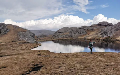
  • 4/5 Roselin Dorado M. 1 year ago on Google
    (Translated by Google) Recommend to those who will visit it for the first time, to bring warm clothes, windbreakers, pimps or turbans, sunglasses and wind protection, gloves, shoes with threshing or special comfortable shoes, wear a jumper and the rest, you already know things that are worn to survive the hike, oh and don't dirty those places... AND ON YOUR TRIPS, DON'T FORGET TO BRING BREAD OR CROQUETTES FOR THE ROAD PUPPIES THAT ALWAYS WAIT FOR US! (Original) Recomendar a quienes lo visitarán por primera vez, llevar ropa abrigada, rompevientos, chulo o turbantes, lentes de sol y para el viento, guantes, zapatos con trilla o especiales cómodos, llevar buso y lo demás ya saben cosas que se llevan para sobrevivir la caminata, ah y no ensuciar esos lugares... Y EN SUS VIEAJES, NO OLVIDEN LLEVAR PAN O CROQUETAS PARA LOS PERRITOS DE LA CARRETERA QUE SIEMPRE NOS ESPERAN!
    3 people found this review helpful 👍

  • 5/5 Luis Eduardo Delgado C. 2 years ago on Google
    Excelente lugar, un tramo dificil de recorrer(para personas que no esten acostumbradas a caminar largas distancias) pero con vistas inimaginables, hermosas. Recomendado al 100%
    2 people found this review helpful 👍

  • 5/5 Jorge K. 2 years ago on Google
    (Translated by Google) It has an intermediate degree of difficulty because the climb to the peak does not mean being close to the precipice. The best view of the city of Cochabamba without a doubt (Original) Tiene un grado de dificultad intermedio por que la subida al pico no supone estar cerca del precipicio. La mejor vista de la ciudad de Cochabamba sin dudas
    1 person found this review helpful 👍

  • 5/5 schawany b. 2 years ago on Google
    (Translated by Google) Rainy season like this it stays (Original) Periodo de lluvias así se queda

  • 5/5 Jhonn Alex Cespedes H. 2 years ago on Google
    (Translated by Google) Beautiful Cochabamba mountain, the Tunari peaks have a height of 5,030 and 5,020 meters above sea level, they are among the highest in Cochabamba, I had opportunities to see the sunrise from peak 5,030, the weather was favorable, it did not rain but it did there was snow, we spent about 30 to 45 minutes at the summit, later it began to snow with more intensity plus hurricane winds, forcing us to descend quickly but very cautiously, between the stones and the snow. (Original) Hermosa montaña cochabambina, los picos del Tunari tienen una altura de 5.030 y 5.020 msnm metros sobre el nivel del mar, están entre los más altos de Cochabamba, tuve oportunidades de ver el amanecer desde el pico 5.030, favoreció el clima, no llovió pero si hubo nieve, estuvimos unos 30 a 45 min en la cumbre, posteriormente empezó a nevar con más intensidad mas vientos huracanados, obligo a bajar apresurados pero con mucha cautela, entre las piedras y la nieve.

  • 5/5 Andrew W. 1 year ago on Google
    (Translated by Google) beautiful 🤩 IG-wildertrails (Original) Hermoso 🤩 IG-wildertrails

  • 5/5 Alexandre M. 8 months ago on Google
    Linda mirada de Cochabamba y del Altiplano. Una hora y media de caminada (no muy facil) desde Laguna Toro.

  • 5/5 Luis Adolfo Mercado P. 9 months ago on Google
    BONITO LUGAR Para ir a acampar a la laguna machu Estar rodeado de naturaleza y estar tranquilo Este lugar es así.. No hay señal de Internet así que tu teléfono dejara de sonar esas horas que estés allá


Open on Google Maps

Trends


Last updated:

Similar Peaks nearby

Last updated:
()