3/5 Jayesh B. 5 months ago on Google
Malegaon
Fort
is
a
land
fort
located
in
the
town
of
Malegaon.
It
is
located
104
km
from
Nashik,
in
Nashik
district,
of
Maharashtra.
The
fort
is
on
the
north
bank
of
the
Mausam
river,
which
is
a
tributary
of
the
Girna
river.
It
was
built
during
the
Maratha
Empire.
--
History
--
Malegaon
Fort
was
constructed
in
1740
by
Naro
Shankar
Raje
Bahadur,
general
of
the
Peshwa.
He
was
appointed
as
an
agent
in
Malwa.
He
was
gifted
18
villages
which
included
Malewadi.
Craftsmen
were
brought
in
from
Surat
and
northern
India
to
build
the
fort,
the
construction
of
which
took
25
years.
After
the
fort
was
completed,
the
craftsmen
settled
in
the
town.
In
1816,
a
Rohilla
sepoy
named
Dilawar
Khan
constructed
the
first
Eidgah
in
the
town.
After
the
fall
of
Trymbakgad
fort
on
24
May
1818,
Malegaon
Fort
was
besieged
on
16
May
1818
by
the
East
India
Company.
--
How
to
reach
--
The
fort
is
located
within
the
town
of
Malegaon.
Malegaon
is
located
on
the
Mumbai-Agra
National
highway
NH-3.
The
fort
is
also
known
as
the
Raje
Bahadur
Wada.
It
is
close
to
the
Ramsetu
bridge.
The
fort
is
open
to
the
public
between
10
am
and
5
pm.
At
present,
there
is
a
Marathi
high
school
in
the
premises
of
the
fort.
--
Places
to
see
--
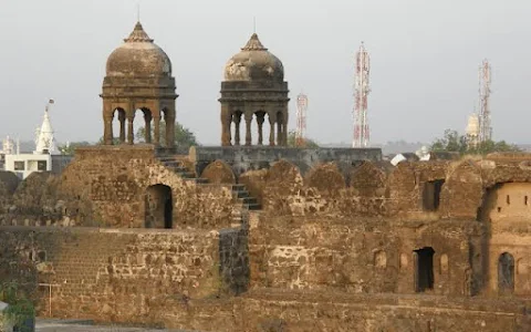
The
fort
is
in
good
condition.
The
height
of
the
inner
wall
is
60
feet.
The
fort
has
lofty
entrance
doors.
The
thickness
of
the
walls
is
about
six
feet.
There
are
two
cannons
at
the
entrance
door
and
a
hexagonal
well
inside
the
fort.
It
takes
about
an
hour
to
see
the
fort.
--
Present
Condition
--
The
fort
is
in
good
condition.
The
height
of
the
inner
wall
is
60
feet.
The
fort
has
lofty
entrance
gates.
The
thickness
of
the
walls
is
about
six
feet.
There
are
two
cannons
at
the
entrance
door
and
there
is
a
hexagonal
well
inside
the
fort.
It
takes
about
an
hour
to
see
the
fort.
In
1740
the
Sardar
of
Peshwas
Naroshankar
built
and
named
it
as
a
Bhuikot
Killa
(fort
that
is
built
on
flat
land
and
not
on
any
mountain),
Bhui
means
Land
in
Marathi.
The
fort
is
now
known
as
Malegaon
Fort.
There
is
no
name
anywhere
or
any
evidence
that
can
prove
that
this
fort
was
built
by
Naroshankar,
says
reports
of
archaeology.
The
fort
is
close
to
the
city
and
as
Malegaon
is
connected
by
the
Mumbai-Agra
highway,
it
is
very
easy
to
access
the
fort.
The
fort
is
very
close
to
Mausam
river.
The
fort
is
in
square
shape
in
100.33
square
metre
area.
There
are
two
security
walls
built
around
the
fort
with
burnt
bricks.
The
walls
are
20
m
in
height
and
3.35
m
width.
Having
a
trench
on
all
its
sides
is
very
important
for
the
security
of
any
land
fort
and
Malegaon
fort
has
it
on
its
four
sides.
By
building
a
wall
partition
in
the
river,
the
water
is
diverted
into
this
trench.
There
was
a
collapsible
bridge
built
on
this
trench.
Only
one
side’s
trench
is
left
presently,
rest
all
have
been
wiped
our
due
to
increased
colonization.
The
fort
had
three
layers
of
fortified
walls.
The
outside
layer
has
lost
in
the
housing
colonies.
Only
one
bastion
to
the
river
side
is
standing
as
of
now.
The
fortified
wall
to
the
west
has
been
cut
to
provide
access
for
the
Kankni
Vidyalala
School
inside
the
fort
premises.
This
is
the
main
entrance
of
the
fort.
After
entering,
we
can
see
the
new
school
building
and
3
canons
in
its
front.
Facing
the
school,
one
can
see
a
space
in
the
two
fort
walls
from
where
the
fort
tour
can
be
started.
The
inside
fort
wall
is
20
feet
high
and
has
9
bastions
in
it.
1 person found this review helpful 👍