4/5 M. W. D. 1 year ago on Google
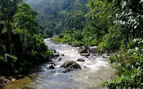
The
river's
headwaters
are
located
in
the
Gongala
Mountain
range,
near
Deniyaya,
bordering
the
Sinharaja
Forest
Reserve.[2]
The
river
flows
past
the
villages
of
Baddegama,
Nagoda,
Thelikada
and
Hegoda.
The
Wakwella
Bridge,
which
was
the
longest
bridge
in
Sri
Lanka,
is
built
over
this
river.
The
river
is
also
dammed
at
Thelikada.
The
mouth
of
the
river
is
at
Gintota,
just
north
of
Galle,
where
it
flows
into
the
Indian
Ocean.
Gin
Ganga
(Sinhala:
ගිං
ගඟ;
Tamil:
கிங்கங்கை)
is
considered
one
of
the
important
rivers
in
southern
Sri
Lanka.
The
chronicle
Mahavamsa
mentions
this
river
as
Galu
Nadi
in
its
chapter
that
describe
the
civil
war
during
the
reign
of
King
Parakramabahu
I
[(1153-1186
A.D.
Nicholas,
1963].
The
river
originates
from
the
Gongala
mountains
in
Deniyaya
(Wickramaarachchi
et
al.,
2012;
Wijesiri,
2015).
It
drains
part
of
the
southern
province
and
passes
Udugama,
Mapalagama,
Agaliya,
and
Baddegama
(Seneviratne,
2011).
After
travelling
about
112.5
km,
it
eventually
empties
into
the
Indian
Ocean
at
Gintota
in
Galle
District
(Seneviratne,
2011;
Wickramaarachchi
et
al.,
2012).
It
annually
discharges
about
1268
million
cubic
meters
to
sea
(Wickramaarachchi
et
al.,
2012).
The
streams
draining
to
Gin
Ganga
include
Holuwagoda
Ela,
Keembi
Ela-
Puhulduwa
Ela,
Galagoda
Puhulduwa
Ela,
Unanviti
Ela,
Mamina
Dola,
Kudawa
Ganga,
Halpatota
Ela
and
Kudubiri
Ela,
Divithura
Ela,
Maben
Ela,
Therun
Ela,
Gonala
Ela,
and
Malamure
Ela
(Seneviratne,
2011).
River
basin
The
Gin
Ganga
river
has
a
catchment
area
of
about
932
km2
(Wickramaarachchi
et
al.,
2012;
Wijesiri,
2015).
Nearly
83%
of
the
catchment
belongs
to
Galle
district
and
the
balance
shared
by
Matara,
Kalutara
and
Ratnapura
Districts
(Wijesiri,
2015).
The
catchment
consists
of
mainly
natural
and
plantation
forest,
agriculture
and
settlements
of
communities
(Wijesiri,
2015)
5 people found this review helpful 👍