5/5 Harsh K N. 4 months ago on Google • 140 reviews
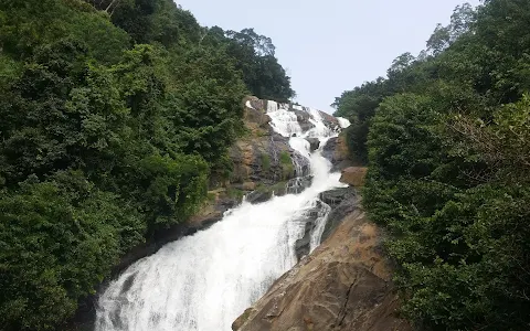
The
30m
fall
forms
part
of
the
Maha
River
that
originates
from
both
sides
of
the Raksawa mountains
and
is
itself
570m
above
sea
level.
The
upper
area
of
the
fall
winds
through
an
area
known
as Uda
Palatha, upstream
of
which
is
the
Divisional
Secretary’s Uduwella GS
area,
in
the
backdrop
of Apalawatte
Pallegama village.
The
fall
forms
a
plunge
pool
strewn
with
rocks
where
people
are
not
encouraged
to
bathe
due
to
the
risk
of
drowning.
Also
at
the
base
of
the
pool
are
crevasses
known
as Pinikandawela and Tissakumarawella that
are
said
to
house
treasure
by
villagers.
The
fall
is
steeped
in
history.
According
to
ancient
books
written
about
border
demarcations,
this
fall
acted
as
a
demarcation
between
the
area
of
Satara
Korale
and
Paranu
Kuru
Korale.
Also,
according
to
folklore,
the
fall
derives
its
name
from
a
desperate
suicide
attempt,
where
a
mounted
monarch
leapt
from
its
upper
reaches.
Villagers
say
that
the
fall
sometimes
emits
a
fearsome
roar
that
can
last
for
15
minutes
and
that
this
signifies
that
it
will
claim
a
human
sacrifice
within
a
two-month
period.
The
fall
is
49km
from Pussalawe and
44km
from Kitugala.
The
upper
reach
is
about
5km
from Dolosbage in
the
Kandy
District
and
can
be
accessed
by
passing
Horawela.
The
foot
of
the
fall
can
be
reached
by
travelling
through Mawanella in
the
Kegale
District,
across
Horawela.
A
four-wheel
drive
vehicle
is
the
best
option.
Horawela
path
can
be
taken
from
the
Mawanella
–
Aranayake
–
Horawela
route
(
B278
route)
or
the
Mawanella
–
Hemanthagama
(B729)
–
Horawela
route.
The
Hemanthagama
route
is
said
to
be
better
than
the
Aranayake
Route.
You
will
need
a
4-wheel
drive
from
Horawela
and
a
good
45-minute
hike
(
1½
km)
to
the
observation
platform.
2 people found this review helpful 👍