5/5 Hugo Leonel Ramos V. 1 month ago on Google • 135 reviews New
FRANCISCO
VELA,
CREATOR
OF
THE
RELIEF
MAP
OF
GUATEMALA
He
was
born
in
Quetzaltenango,
on
7-23-1859,
son
of
Cruz
Vela
and
Antonia
Arango;
died
in
Esquipulas,
Chiquimula,
on
February
28,
1909;
His
first
studies
were
carried
out
in
his
hometown,
entering
the
Polytechnic
School
on
5-4-1875,
where
his
high
academic
level
and
leadership
allowed
him
to
reach
the
rank
of
First
Sergeant
of
the
Company,
graduating
with
the
rank
of
Second
Lieutenant
of
Engineers
and
Surveyor
at
19
years
old.
In
his
first
assignment,
he
returned
to
Quetzaltenango
to
provide
his
services
with
dedication
and
care,
deepening
his
topographical
studies,
in
addition
to
teaching
classes
to
youth;
He
studied
at
the
American
School
of
Correspondence
in
Philadelphia,
United
States,
obtaining
the
title
of
Telegraph
Engineer
and
then
Municipal
Administrator,
being
also
a
member
of
the
Academy
of
Sciences
of
the
Ateneo
de
Guatemala.
Author
of
books
referring
to
the
topics
of
mathematics,
topography
and
geography,
he
was
also
editor
of
the
Magazine
La
Propaganda
Cientifica
to
which
he
dedicated
time
and
effort;
His
remarkable
numerical
ability
inspired
him
to
learn
the
use
of
the
Chinese
abacus,
dedicating
himself
to
building
similar
devices,
with
which
it
was
possible
to
perform
complex
operations
and
equations
of
different
degrees.
He
completed
his
studies
at
the
Polytechnic
School
of
Guatemala
where
he
graduated
as
a
Topographical
Engineer
on
1-23-1882.
He
stood
out
for
his
mastery
of
Mathematics,
his
studies
of
the
decimal
metric
system
and
his
works
on
national
geography.
He
was
Director
of
the
Polytechnic
School
between
1889
and
1891,
dean
of
the
Faculty
School
of
Engineering
from
1898
to
1902,
and
during
the
government
of
President
Manuel
Lisandro
Barillas
he
was
elected
deputy
to
the
National
Legislative
Assembly
as
a
representative
of
Quetzaltenango.
In
addition,
he
published
the
work
Data
of
the
Republic
of
Guatemala
in
1908.
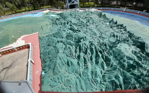
Without
a
doubt
his
most
extraordinary
work
was
the
creation
of
the
Relief
Map
of
Guatemala,
which
can
be
seen
in
the
Hipódromo
del
Norte
in
Guatemala
City.
This
map
was
inaugurated
on
10-29-1905
and
has
been
considered
one
of
the
most
valuable
assets
of
Guatemalan
cultural
heritage.
In
1888,
carrying
out
one
of
his
countless
measurements
of
the
national
territory
at
the
top
of
Zunil,
he
formalized
the
idea
of
creating
a
Relief
Map
of
the
Republic.
In
May
1903,
he
was
called
by
then-president
Manuel
Estrada
Cabrera,
also
a
Quetzaltecan,
to
plan
the
gardens
of
the
Hipódromo
del
Norte,
which
was
Vela's
opportunity
to
carry
out
his
project.
When
the
president
asked
him
to
be
the
one
to
place
the
first
stone,
Colonel
Vela
replied:
"Mr.
President,
you
will
be
the
one
who
places
the
last
one!"
Estrada
Cabrera
was
surprised
by
the
unusual
response,
but
he
was
pleased
with
it,
since
it
meant
that
Colonel
Vela
was
committed
to
finishing
the
project.
Thus,
in
April
1904,
the
laying
of
the
foundations
began.
The
Relief
Map
was
completed
in
18
months,
for
many
a
record
time,
which
included
not
only
the
construction
itself,
but
also
the
previous
journey,
throughout
the
length
and
breadth
of
the
country,
sometimes
by
mule,
other
times
on
foot,
by
road.
the
railway
or
boat
route
through
navigable
rivers,
carried
out
by
the
engineer
Francisco
Vela,
creator
of
the
design.
Vela
carried
out
this
task
in
order
to
achieve
the
most
accurate
possible
scale
of
mountains,
volcanoes,
valleys,
basins,
rivers,
lakes,
coasts,
ports,
cities,
roads
and
railways,
measured
with
the
cartographic
instruments
available
at
the
beginning
of
the
20th
century.
To
execute
his
work
he
sought
the
support
of
the
engineer
Claudio
Urrutia
and
the
artist
Antonio
Doninelli,
who
together
with
the
workers
would
give
life
to
the
geographical
representation
of
Guatemala.
The
map
cost
5
thousand
gold
pesos.
On
10-29-1905,
with
martial
bands
and
more
than
six
thousand
children
parading,
followed
by
the
military
parade,
Francisco
Vela's
masterpiece
was
inaugurated
by
President
Manuel
Estrada
Cabrera,
who
placed
the
last
stone
during
the
ceremony.
Posted
by
C.H.G.