4/5 Jimmie C. 3 years ago on Google
(Translated
by
Google)
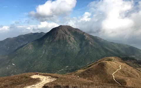
Phoenix
Mountain
to
watch
the
sunrise!
Since
I
heard
that
Dawei
has
been
there,
the
second
highest
peak
in
Hong
Kong,
934
meters!
On
Saturday,
I
asked
him
to
take
the
Lantau
Island
bus
to
Pak
Kung
Au,
and
it
is
correct.
It
is
also
at
an
altitude
of
340.8
meters.
The
Dadongshan
mountain
is
an
important
meeting
point!
Gangshang
talks
here,
stretches
and
slopes
easily
D,
Ngong
Ping
has
a
short
distance
but
has
to
climb
the
ladder
(1km
to
climb
350
meters
😅),
the
scenery
is
beautiful,
Looking
at
both
sides
of
the
Changsha
Shuikou
in
Tung
Chung
of
the
airport,
I
walked
slowly
for
2
minutes
to
the
top
of
the
mountain.
Unfortunately,
it
was
a
heavy
fog.
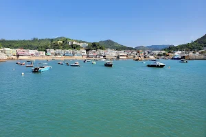
After
that,
I
went
to
Ngong
Ping
Market
for
1
Zhongluoshan.
The
water
was
calm
and
the
geese
flew.
When
I
had
time
and
strength,
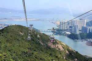
I
decided
to
walk
along
the
360
cable
car.
The
Ngong
Ping
plank
road
is
about
6km
away
from
Tung
Chung.
Many
sections
of
the
road
are
built
with
wooden
planks
on
the
mountain,
and
the
tree
sounds
along
the
way
are
good,
but
if
you
go
up
the
mountain,
it
will
be
a
bit
sweet,
because
you
have
to
climb
555
meters
high
first
to
Ngong
Ping!
(The
whole
journey
is
about
13km)
(Original)
鳳凰山睇日出!由細聽到大未去過,香港第2高峰,934米!星期六求其搭架大嶼山巴士係伯公坳落,無錯,又係海拔340.8米高嘅伯公坳落車,上869米嘅大東山都係,重要嘅交匯點嘛!綱上話這邊上拉長上斜輕鬆D,昂平上路程短D但要上天梯(1km要攀升350米😅),原來風景咁靚,機場東涌長沙水口兩邊望哂,慢行2個鐘到山頂,可惜大霧,之後行1個鐘落山去昂平市集,水靜鵝飛,仲有時間同体力,決定沿360纜車走,行約6km嘅昂坪棧道落東涌,路段好多係依山用木板搭建,好好行沿途樹音,但如果係上山就幾甘,因要上555米高先到昂平!(全程約13km)