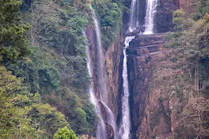
5/5 dashen G. 3 years ago on Google
(Translated
by
Google)
A
snowy
place
in
Sri
Lanka
????
😍🥶❄️☃️🍃🌿💦
♥
️🇱🇰
Yes
this
is
a
beautiful
paradise
on
the
Pussellawa
side
with
minus
temperatures
..
There
is
evidence
behind
the
photos
..
It
means
to
have
a
cold
camping
experience
when
the
flowers
are
frozen
despite
the
snow
හිම
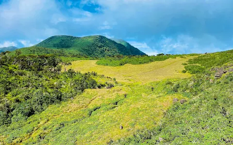
Iravana's
Cart
Road
-
"Chariot
Path"
CHARIOT
PATH
OF
KING
RAWANA.
Chariot
Path
is
a
plain
in
Nuwara
Eliya
District.
It
is
believed
that
this
is
the
place
where
King
Rawana
showed
Princess
Sita
the
beauty
of
Ceylon
after
she
was
brought
there.
Chariot
Path
is
also
known
as
the
route
taken
by
Ravana's
chariot
located
at
the
Ramboda
end
of
the
Pidurutalagala
mountain
range.
To
this
day
no
vegetation
is
cultivated
in
the
plain
and
it
consists
only
of
grass.
Is
another
legend.
This
mountain
range
is
located
at
an
altitude
of
more
than
2100
m
above
sea
level
and
is
very
similar
to
the
Maha
Eliya
Plain
or
Horton
Plains
Park.
The
Pidurutalagala
Reserve
is
located
on
one
side
and
the
Kotmale
Oya
on
the
other
side.
From
here,
Sri
Pada,
Pidurutalagala,
Kikiliyamana,
Peekok
Hill,
Kotgala,
Grigala.
It
offers
beautiful
views
of
the
central
highlands,
including
the
mountains.
The
specialty
here
is
a
small
pond
at
one
end
of
the
plain
that
does
not
dry
up
even
during
severe
droughts.
According
to
the
folklore,
this
pond
was
created
from
the
tears
of
Goddess
Sita
who
was
brought
by
Ravana
and
the
villagers
believe
that
this
pond
will
not
dry
up
even
during
any
severe
drought.
Like
our
page
and
join
us.
Experience
the
wonders
of
the
most
beautiful
places
like
this
in
Sri
Lanka
ව
Stop
..
the
place
where
the
mind
asks.
#copied
#SriLanka
#nawathuma
#travel
#hiking
#camping
#travelphotography
#wonderofasia
📸
goes
to
respective
owners
(Original)
ලංකාවේ
හිම
වැටෙන
තැනක්????
😍🥶❄️☃️🍃🌿💦♥️🇱🇰
ඔව්
මේ
උෂ්ණත්වය
ඍණ
ගණන්
(
minus
temperature
)
යන
පුස්සැල්ලාව
පැත්තේ
තියෙන
ලස්සනම
පාරාදීසයක්..
🤩💚🌏🇱🇰
Photos
අස්සේ
තියෙනවා
සාක්ෂිත්
එක්කම..
හිම
කිව්වාට
මල්
තුහින
පිපෙන
සීතලේ
camping
අත්දැකීමක්
ගන්නවා
කියන්නේ
ඉතින්
😍🏕
📌රාවණාගේ
කරත්ත
පාර
-
"චැරියට්
පාත්"
CHARIOT
PATH
OF
KING
RAWANA.
චැරියට්
පාත්
යනු
නුවරඑලිය
දිස්ත්රික්කයේ
පිහිටි
තැනිතලාවකි.
රාවණ
රජතුමා
සීතා
කුමරිය
ගෙන
ආ
පසු
ලංකාවේ
සුන්දරත්වය
ඇයට
පෙන්වූ
ස්ථානය
එය
යැයි
ජනයා
විශ්වාස
කෙරේ.
පිදුරුතලාගල
කඳු
පන්තියේ
රම්බොඩ
අන්තයේ
පිහිටා
ඇති
රාවණාගේ
කරත්තය
ගමන්
කළ
මාර්ගය
ලෙසද
චැරියට්
පාත්
හදුන්වයි.
අද
වන
තුරු
තැනිතලාවේ
කිසිදු
වෘක්ෂලතාදිය
වගා
නොකරන
අතර
එය
තණකොළ
වලින්
පමණක්
සමන්විත
වේ.රාවණා
රජු
විසින්
සීතා
දේවිය
“ලංකාපුර”
අගනුවර
සිට
“අශෝක
විටක”
නම්
ස්ථානය
වෙත
රැගෙන
යන
අතර
වාරයේදී
මෙම
ස්ථානය
හරහා
තම
රිය
ගෙන
ගිය
බවත්,
එවිට
මෙම
ස්ථානය
නිර්මාණය
වූ
බවත්
තවත්
ජනප්රවාද
වල
සදහන්
කථාවක්
වෙයි
.
මහඑළිය
තැන්න
හෙවත්
හෝර්ටන්
තැන්න
උද්යානයට
බොහෝ
සමානකම්
දක්වන
පරිසර
පද්ධතියක්
වන
මෙම
කඳු
වැටිය
මුහුදු
මට්ටමේ
සිට
මීටර්
2100
කට
වඩා
උසකින්
පිහිටා
ඇත.
මෙම
මනස්කාන්ත
බිම්කඩ
වටා
එක්
පසකින්
පිදුරුතලාගල
රක්ෂිතයත්,
තවත්
පසකින්
කොත්මලේ
ඔයත්,
තවත්
පසකින්
හේවාහැට
හඟුරන්කෙත
ප්රදේශයත්,
පිහිටා
ඇති
අතර
මෙහි
සිට
ශ්රී
පාදය,
පිදුරුතලාගල,
කිකිලියාමාන,
සිංගල්
ත්රී,
පීකෝක්
හිල්,
කොත්මලේ,
ග්රේට්වෙස්ටන්,
රිකිල්ලගස්කඩ,
කුකුළාගල,
රන්දෙණිගල
ජලාශය,
දොළොස්බාගේ
කඳු
ඇතුළුව
මධ්යම
කඳුකරයේ
සුන්දර
දසුන්
විවර
කරයි.
මෙහි
විශේෂත්වය
වන්නේ
දැඩි
නියඟ
කාලවලදී
පවා
වියළී
නොයන
මෙම
තැනිතලාවේ
එක
කෙළවරක
පිහිටා
ඇති
වතුර
පිරුණු
කුඩා
පොකුණයි.
ජනප්රවාදයට
අනුව
මෙම
පොකුණ
රාවණා
ගෙනා
ආ
සීතා
දේවියගේ
කඳුලු
වලින්
නිර්මාණය
වී
ඇති
අතර
කිසිදු
උග්ර
නියං
සමයකදී
වුවද
මෙම
පොකුණ
නොසිඳෙන
බව
ගම්වාසීන්
විශ්වාස
කරයි.
💚
අපේ
පේජ්
එකටත්
ලයික්
එකක්
දාල
එකතු
වෙන්න
අපිත්
එක්ක.ලංකාවේ
මේ
වගේ
ලස්සනම
තැන්
වල
අසිරිය
විඳගන්න
👉
නැවතුම..
හිත
ඉල්ලන
තැන.
#copied
#SriLanka
#nawathuma
#travel
#hiking
#camping
#travelphotography
#wonderofasia
📸
goes
to
respective
owners