5/5 Hashan R. 1 year ago on Google
Most
of
the
battles
to
invade
the
Kandyan
Kingdom
took
place
at
Balana
(literal
translation
viewing
point),
with
the
Kandyan
monarchs
emerging
victorious
aided
by
the
impenetrable
mountain
formations.
The
famous
Balana
Fort
which
functioned
as
a
strategic
rock
fortress
and
an
outpost
to
Kandyan
kingdom
was
built
between
Kadugannawa
Pass[1]
and
Alagalla
Mountain
Range....
.
.
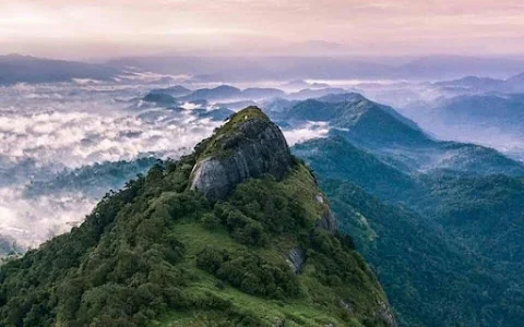
Alagalla
Mountain
Range
is
located
in
Mawanella
which
is
on
the
borders
of
the
Central
and
Sabaragamuwa
Provinces.
Alagalla
mountain
is
surrounded
by
well-known
mountains
such
as
Bathalegala
also
known
as
Bible
Rock,
Uthuwankanda,
Devanagala,
Ambuluwawa,
Knuckles
Mountain
Range,
and
Hanthana
Mountain
Range.
Alagalla
is
a
popular
hiking
destination
among
local
travelers
and
a
huge
number
of
hikers
cross
this
mountain
on
the
Independence
Day
of
Sri
Lanka.
You
can
see
a
clear
view
of
this
mountain
during
the
Kandy–
Colombo
railway
journey
because
the
Colombo-Kandy
railway
line
runs
at
the
bottom
of
the
mountain.
The
elevation
of
the
highest
point
of
Alagalla
is
1140m
above
sea
level.
This
mountain
range
also
served
as
a
natural
defense
location
for
nearly
five
centuries
from
1505
to
1948
against
Portuguese,
Dutch,
and
English
invasions
aimed
at
the
Kandyan
Kingdom..
❤😍
6 people found this review helpful 👍