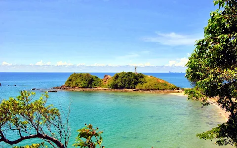
5/5 Busoko T. 3 years ago on Google
(Translated
by
Google)
Mu
Koh
Lanta
National
Park
is
located
in
Koh
Lanta
district.
Krabi
Province
It
consists
of
25
islands,
which
can
be
divided
into
4
groups:
Koh
Rok
group
consisting
of
Koh
Rok
Nok
and
Koh
Rok
Nai.
Koh
Rok
Nai
has
a
general
landscape
with
steep
cliffs
and
rocks
that
have
been
eroded
for
a
long
time
in
the
north.
The
side
facing
west
is
a
long
cliff.
The
front
of
the
island
is
approximately
2.4
kilometers
long,
the
highest
peak
is
208
meters
above
sea
level.
Koh
Rok
Nok
is
an
island
that
is
similar
in
size
to
Koh
Rok
Nai.
The
highest
peak
is
156
meters
above
sea
level.
In
the
area
between
the
gorges
there
are
two
wide
plains,
namely
Had
Talu
Gorge.
And
Man
Sai
Bay
The
geothermal
conditions
of
the
Rok
Islands
are
in
the
Permian-Carboniferous
period.
The
age
ranges
from
345-230
million
years
ago.
Koh
Ha
Group
(Koh
Tukn
Lima)
and
Koh
Hin
Daeng
The
Haa
group
consists
of
five
small
islands,
slightly
plains
on
the
hilltop
of
the
two
large
islands
and
the
remaining
three
are
rocky
outcrops.
No
flat
area
Geological
characteristics
of
this
island
group
It
is
a
limestone
in
the
Ratchaburi
series
rocks
during
the
Lower-Middle
Permian
period,
with
a
period
of
280-230
million
years
old.
Koh
Ngai
Group
consists
of
Koh
Ngai
and
Koh
Ma
in
front
of
the
islands
to
the
east
of
Koh
Ngai
consists
of
long
sandy
beaches.
South
of
the
bay
The
north
west
side
looks
like
a
steep
hill.
The
highest
peak
is
198
meters
above
sea
level.
For
Koh
Ma
looks
like
a
rock
outcrop
in
the
water
No
flat
area
The
geologic
conditions
of
this
group
of
islands
in
general
are
the
same
as
those
of
Koh
Rok.
Koh
Lanta
Group
It
consists
of
16
large
and
small
islands,
including
Koh
Lanta
Yai,
Koh
Taling,
Koh
Mai
Ngam,
etc.
The
topography
of
Koh
Lanta
Yai
is
a
complex
mountain.
And
quite
steep
Plains
appear
only
on
the
beaches
in
the
south.
Most
of
the
area
has
more
than
35
percent
slope
to
the
central
part
of
the
island
with
more
than
50
percent
slope,
heights
from
sea
level
100
meters
to
the
highest
peak
in
the
middle
of
the
area
at
488
meters.
For
other
islands
There
is
a
state
of
steep
rock.
No
plain
appears
Geological
characteristics
of
the
Koh
Mai
Ngam
area
Koh
Mai
Ngam
Tai
Looks
like
water
sediment
Sediment
And
sediments
in
the
wetlands
In
the
Holocene
period
For
the
area
of
Ko
Ra
Pu
Pang,
Koh
Lapule
and
Koh
Talabeng
It
has
the
same
geological
characteristics
as
the
five
islands.
And
the
geologic
characteristics
of
Koh
Lanta
Yai
are
the
same
as
the
Koh
Rok
group
On
Koh
Lanta
Yai
there
are
many
streams
of
water
running.
But
often
dehydrated
during
the
dry
season
There
are
only
3
streams
that
carry
water
throughout
the
year:
the
Inland
Canal
and
the
Nin
Canal.
(Original)
อุทยานแห่งชาติหมู่เกาะลันตาตั้งอยู่ในท้องที่อำเภอเกาะลันตา
จังหวัดกระบี่
ประกอบด้วยเกาะ
25
เกาะ
สามารถแบ่งออกได้เป็น
4
กลุ่ม
ได้แก่
กลุ่มเกาะรอก
ประกอบด้วย
เกาะรอกนอก
และเกาะรอกใน
ซึ่งเกาะรอกในมีภูมิประเทศทั่วไปเป็นหินผาสูงชันมีโขดหินที่ถูกกัดกร่อนมาเป็นเวลานานอยู่ทางทิศเหนือ
ด้านที่หันสู่ทิศตะวันตกเป็นหน้าผาทอดยาว
ด้านหน้าของเกาะมีความยาวประมาณ
2.4
กิโลเมตร
ยอดเขาที่สูงที่สุด
สูง
208
เมตรจากระดับน้ำทะเล
ส่วนเกาะรอกนอกเป็นเกาะที่มีขนาดใกล้เคียงกับเกาะรอกใน
ยอดเขาที่สูงที่สุด
สูง
156
เมตรจากระดับน้ำทะเล
บริเวณระหว่างช่องเขาจะมีที่ราบขนาดกว้างอยู่
2
แห่ง
คือ
ช่องเขาหาดทะลุ
และอ่าวม่านไทร
สภาพธรณีของกลุ่มเกาะรอกอยู่ในยุคเพอร์เมียน-คาร์บอนิเฟอรัส
มีช่วงอายุตั้งแต่
345-230
ล้านปีมาแล้ว
กลุ่มเกาะห้า
(เกาะตุกนลิมา)
และเกาะหินแดง
กลุ่มเกาะห้าประกอบด้วยเกาะเล็กๆ
5
เกาะ
มีที่ราบเล็กน้อยบนยอดเขาของเกาะที่มีพื้นที่มาก
2
เกาะ
และอีก
3
เกาะที่เหลือมีลักษณะเหมือนหินโผล่พื้นน้ำ
ไม่มีพื้นที่ราบ
ลักษณะทางธรณีของกลุ่มเกาะนี้
เป็นหินปูนในหินชุดราชบุรีในยุคเพอร์เมียนช่วงล่าง-ช่วงกลาง
มีช่วงอายุ
280-230
ล้านปี
กลุ่มเกาะไหง
ประกอบด้วย
เกาะไหง
และเกาะม้า
ด้านหน้าเกาะทางทิศตะวันออกของเกาะไหงประกอบด้วยหาดทรายยาวเหยียด
ทิศใต้ลักษณะเป็นอ่าว
ด้านตะวันตกตอนเหนือมีลักษณะเป็นเขาสูงชัน
ยอดเขาสูงที่สุด
สูง
198
เมตรจากระดับน้ำทะเล
สำหรับเกาะม้ามีลักษณะเหมือนหินโผล่พื้นน้ำ
ไม่มีพื้นที่ราบ
สภาพทางธรณีของกลุ่มเกาะนี้โดยรวมมีลักษณะเช่นเดียวกับกลุ่มเกาะรอก
กลุ่มเกาะลันตา
ประกอบด้วยเกาะใหญ่น้อยจำนวน
16
เกาะ
ได้แก่
เกาะลันตาใหญ่
เกาะตะละเบ็ง
เกาะไม้งาม
เป็นต้น
ลักษณะภูมิประเทศของเกาะลันตาใหญ่เป็นภูเขาสลับซับซ้อน
และค่อนข้างลาดชัน
ที่ราบปรากฏเฉพาะบริเวณชายหาดทางตอนใต้
พื้นที่ส่วนใหญ่มีความลาดชันมากกว่า
35
เปอร์เซ็นต์
ไปจนถึงบริเวณตอนกลางของเกาะที่มีความลาดชันมากกว่า
50
เปอร์เซ็นต์
ความสูงจากระดับน้ำทะเลตั้งแต่
100
เมตร
ไปจนถึงยอดเขาสูงที่สุดตอนกลางของพื้นที่ที่มีความสูง
488
เมตร
สำหรับเกาะอื่นๆ
มีสภาพเป็นโขดหินสูงชัน
ไม่มีที่ราบปรากฏ
ลักษณะธรณีของบริเวณเกาะไม้งาม
เกาะไม้งามใต้
มีลักษณะเป็นตะกอนน้ำพา
ตะกอนชะวากทะเล
และตะกอนที่ลุ่มที่ราบชายเลน
ในสมัยโฮโลซีน
สำหรับบริเวณเกาะร่าปูพัง
เกาะลาปูเล
และเกาะตะละเบ็ง
มีลักษณะธรณีโดยรวมเช่นเดียวกับกลุ่มเกาะห้า
และลักษณะธรณีของบริเวณเกาะลันตาใหญ่ก็เช่นเดียวกับกลุ่มเกาะรอก
บนเกาะลันตาใหญ่มีลำธารน้ำไหลซึ่งมีน้ำไหลอยู่หลายแห่ง
แต่มักขาดน้ำในช่วงฤดูแล้ง
โดยมีลำธารเพียง
3
สาย
ที่มีน้ำไหลอยู่ตลอดปี
ได้แก่
คลองจาก
คลองน้ำจืด
และคลองนิน
2 people found this review helpful 👍