4/5 Jasve 3 years ago on Google
(Translated
by
Google)
A
great
tip
for
people
who
want
to
go
to
the
kestrel
ravine
DO
NOT
PUT
ON
YOUR
GOOGLE
MAPS
THAT
YOU
WANT
TO
GO
TO
THE
KESTNIC
RAILWAY
IF
YOU
WANT
TO
GO
TO
THE
FAMOUS
WATERFALLS
THAT
ARE
IN
THAT
PLACE,
you
have
to
put
in
google
maps
that
you
want
to
go
TO
MERENDERO
DE
LOS
CERNÍCALOS
AND
IN
THIS
WAY
IT
WILL
TAKE
YOU
TO
THE
STARTING
POINT
TO
START
WALKING
TOWARDS
THE
WATERFALLS,
because
if
you
put
in
google
maps
the
barranco
de
los
cernícalos
the
map
will
take
you
to
the
upper
part
of
the
ravine
by
car
but
the
road
is
practically
impassable
for
small
and
medium-sized
cars
and
if
you
take
an
off-road
vehicle
you
have
to
wear
tires
exclusively
for
the
mountains,
because
the
road
is
not
paved
two
or
three
kilometers
from
the
end,
the
last
kilometer
and
a
half
has
a
brutal
upward
incline,
it
is
full
of
holes
quite
deep
and
the
terrain
itself
is
very
slippery.
When
you
go
to
the
kestrel
picnic
area,
google
maps
will
take
you
exactly
to
the
starting
point
to
start
the
walk
to
the
kestrel
ravine,
since
with
the
car
you
will
not
be
able
to
go
to
the
waterfalls.
The
walk
from
where
you
leave
the
car
to
the
waterfalls
is
4
km
walking
and
if
it
is
really
worth
going
even
once
in
your
life,
you
will
find
places
that
seem
to
transport
you
to
other
places
and
make
you
forget
that
you
are
in
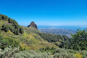
Gran
Canaria
already
a
few
kilometers
from
the
city
of
telde,
it
is
recommended
to
go
with
the
family,
although
there
are
many
people
who
also
bring
their
dogs
,,,.
In
total
there
are
three
waterfalls,
the
first
that
you
are
going
to
find
is
the
smallest
and
it
is
a
bit
hidden
and
the
height
of
the
waterfall
is
small,
then
following
the
path
up
you
will
find
the
second
which
is
the
medium
waterfall
that
you
can
find
there
make
a
stop
to
rest,
eat
and
take
a
bath
by
getting
down
the
waterfall
that
this
one
if
it
has
an
adequate
height
to
say
that
you
have
bathed
under
a
waterfall
:),
and
going
up
a
little
higher
you
will
find
the
largest
in
both
fall
height
of
the
water
as
in
width
that
to
reach
it
you
will
have
to
climb
an
area
with
an
incline
that
I
believe
is
dangerous
to
go
up
and
down
with
children.
But
apart
from
everything
said
above
and
also
highlight
that
there
is
no
clear
signposting
to
get
to
the
different
waterfalls,
I
recommend
the
place,
me
and
my
family
loved
it.
I
recommend
mountain
footwear
and
if
you
carry
a
small
first-aid
kit
with
the
essentials,
even
better.
(Original)
Un
gran
consejo
para
las
personas
que
quieren
ir
al
barranco
de
los
cernícalos
NO
PONGÁIS
EN
EL
GOOGLE
MAPS
QUE
QUEREIS
IR
AL
BARRANCO
DE
LOS
CERNÍCALOS
SI
QUEREIS
IR
A
LAS
FAMOSAS
CASCADAS
QUE
ESTÁN
EN
ESE
LUGAR,
teneis
que
poner
en
google
maps
que
quereis
ir
a
MERENDERO
DE
LOS
CERNÍCALOS
Y
DE
ESTA
MANERA
OS
LLEVARÁ
AL
PUNTO
DE
INICIO
PARA
EMPEZAR
A
CAMINAR
HACIA
LAS
CASCADAS,
porque
si
ponéis
en
google
maps
barranco
de
los
cernícalos
el
mapa
os
llevará
a
la
parte
alta
del
barranco
en
coche
pero
el
camino
es
practicamente
intransitable
para
los
coches
pequeños
y
medianos
y
si
llevais
un
veh
todoterreno
teneis
que
llevar
neumáticos
exclusivamente
para
montaña,porque
la
via
no
está
asfaltada
a
dos
o
tres
kilometros
del
final,
el
último
kilometro
y
medio
tiene
una
inclinación
ascendente
brutal,está
lleno
de
hoyos
bastantes
profundos
y
el
terreno
en
sí
es
muy
deslizante.
Al
poner
ir
al
merendero
de
los
cernícalos
google
maps
os
llevará
exactamente
al
punto
de
inicio
para
empezar
la
caminata
hacia
el
barranco
de
los
cernícalos,ya
que
con
el
coche
no
podréis
ir
hasta
las
cascadas.
La
caminata
de
donde
dejáis
el
coche
a
las
cascadas
es
de
4
km
caminando
y
realmente
Si
vale
la
pena
ir
aunque
sea
una
vez
en
la
vida,encontrareis
lugares
que
parece
que
te
transportan
a
otros
lugares
y
te
hacen
olvidar
que
estaís
en
gran
canaria
y
a
pocos
kilómetros
de
la
ciudad
de
telde,es
recomendable
para
ir
en
familia
,aunque
hay
bastantes
personas
que
llevan
también
a
sus
perros,,,.
En
total
hay
tres
cascadas,la
primera
que
os
vaís
a
encontrar
es
la
más
pequeña
y
está
un
poco
oculta
y
la
altura
de
la
caida
del
agua
es
pequeña,luego
siguiendo
el
camino
subiendo
encontraréis
la
segunda
que
es
la
cascada
mediana
que
en
ella
podéis
hacer
una
parada
para
descansar,comer
y
daros
un
baño
metiendoos
baja
la
cascada
que
esta
si
que
tiene
una
altura
adecuada
para
decir
que
os
habéis
bañado
bajo
una
cascada:),y
subiendo
un
poco
más
arriba
encontrareis
la
mas
grande
tanto
en
altura
de
caida
del
agua
como
en
anchura
que
para
llegar
a
ella
tendréis
que
subir
por
una
zona
con
una
inclinación
que
yo
creo
que
es
peligrosa
para
subir
y
bajar
con
niños.
Pero
a
parte
de
todo
lo
dicho
anterior
y
también
resaltar
que
no
hay
señalización
clara
para
llegar
a
las
diferentes
cascadas,el
lugar
lo
recomiendo,a
mí
y
a
mi
familia
les
encantó.
Os
recomiendo
calzado
de
montaña
y
si
lleváis
un
pequeño
botiquín
con
lo
esencial
mejor
aún.
5 people found this review helpful 👍