Calico Tanks Trail image

Calico Tanks Trail

Tourist attraction Hiking area

One of the Top rated Hiking areas in Clark County


Address

Calico Tanks, Las Vegas, NV 89161, United States

Website

www.redrockcanyonlv.org

Contact

+1 702-515-5350

Rating on Google Maps

4.90 (349 reviews)

Open on Google Maps

Working Hours

  • Friday: 6 am to 8 pm
  • Saturday: 6 am to 8 pm
  • Sunday: (Easter), 6 am to 8 pm, Hours might differ
  • Monday: 6 am to 8 pm
  • Tuesday: 6 am to 8 pm
  • Wednesday: 6 am to 8 pm
  • Thursday: 6 am to 8 pm

Featured Reviews


Frequently mentioned in reviews: trail (57) hike (38) view (14) easy (13) rocks (11) climbing (11) hiking (11) rock (11) views (10) Calico (8)
Reviews are sorted by relevance, prioritizing the most helpful and insightful feedback at the top for easier reference.
  • 5/5 Abhirup D. 2 years ago on Google
    Strenuous but very cool trail. The hike starts out very easy with the first mile being mostly a flatland walk. You start going up the rocks midway through the hike and it can be very challenging if you don’t have proper gear. There are some sections that might even require some climbing. The trail itself is very well marked, however there’s no marking at the top. We hiked a little past the tank of Calico tanks and the views from the mountain top were absolutely stunning (photos added). Overall, hard but worthy hike. If you have to do one hike in the Red Rock area I’d recommend you pick this one.
    10 people found this review helpful 👍

  • 5/5 J G. 1 year ago on Google
    Fantastic scenery in the Red Rocks. You will need a National Park pass, a Red Rock pass or $15 per car to enter. Whatever you choose can be purchased at the park entrance. No reservation required until the Fall of 2022. Definitely considered a moderate hike as it requires sure footing and a little bouldering. Tennis shoes or hiking shoes highly recommended. The trail is well marked, but you’ve got to keep your eye out for the markers as it’s easy to get a little off the beaten path. AllTrails is a great companion to keep you out of trouble. Download the trail before you begin as internet connectivity is sketchy. The desert is hot. Go early. The mountain will provide just enough shade before 9am. Once the sun is fully risen there is no respite from its rays. Take a lot of water. Hydration matters. Your IG posts will get lots of likes. Have fun!
    6 people found this review helpful 👍

  • 5/5 Hugh K. 2 years ago on Google
    This trail is absolutely awesome and worth tons! Definitely must try out when visiting Red Rock Canyon. Not 100% sure but you may be waived the entrance fee if you enter before 8 AM (depends on dates, but for my case I did not pay any fees at 750 AM on MLK day). If you like to see mysterious foggy city view morning should be a good time and best for no heat. The last portion of the trail gets pretty hard because of narrow and slippery rock steps but it is definitely worth it. Total 2 hours or a half hour more for a round trip. If you are not familiar with hiking, take more breaks. Will visit again!
    5 people found this review helpful 👍

  • 5/5 Tim 3 years ago on Google
    This was my favorite hike at this park. The main trail is easy. The only challenge being physical. The elevation parts were all stair stepped with flat rocks. I took some side trails down that was more difficult with quite a bit of rock scrambling and some amazing views.
    4 people found this review helpful 👍

  • 5/5 Yuya B. 3 years ago on Google
    One of my favorite trails ever. Easy access from a large parking lot with bathrooms. There’s no running water so fill up at the visitor center. None of the trail is paved and is a mix of gravel, desert sand, and rocks. Minimal elevation change of 400ft. Mild-moderate difficulty easy to be challenging but fun for beginners and children. No dangerous drop offs other than the calico view at the end overlooking the view.
    2 people found this review helpful 👍

  • 5/5 Nicholas M. 3 years ago on Google
    Challenging, gorgeous trail that's well worth the $15/$17 park fee (vehicle) alone. Expect to spend at least two hours doing a roundtrip hike here. You definitely have to scramble at some points, particularly towards the end - but you're rewarded with a sweeping vista of the canyon and Vegas off in the distance. A good portion of the trail is in the shade; it can get very chilly with the wind in the winter months so bring an extra jacket and/or a hat!
    2 people found this review helpful 👍

  • 5/5 Loren S. 1 year ago on Google
    Just a magical hike, you would think you are on another planet. There is some rock scramble, so do not expect a easy path. For sure a top five short hike that I have ever done.
    2 people found this review helpful 👍

  • 5/5 Claudine M. 1 year ago on Google
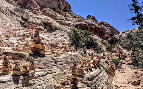
    #CalicoTanks is our final hike to our #RedRockCanyon adventure! I'm always asked why do we always go hiking? The real question is, why aren't you? If you're addicted to beautiful views and the challenge, being at the not-so-young age, then you'd know why! 🤪✌️ • 🎈Calico Tanks Trail *Trail Difficulty: Strenuous *Trail Distance: 2.2 miles RT *Elevation Gain: 406 ft *Trailhead: Sandstone Quarry Parking Lot *Time Required: 2.5 hrs (excluding stops) ⚠️ Best time to go is between October to April. Cellphone signal is weak so download the map or the app #AllTrails in advance. Prepare to use both hands when scrambling to avoid slips and falls. It is discouraged to hike this trail for 24 hours after a rain, flash flooding may occur during/after desert rain. Bring food and water, wear hiking shoes and a hat, and do not disturb or feed wildlife. • This rush hike over red sandstone walls leads to a hidden water pocket and a great view of the Las Vegas valley. As the most popular trail in Red Rock Canyon, expect other hikers along the way. This hike combines elements of the history, geology, beauty, and fun that makes Red Rock Canyon famous! The first 30 yards of the trail is shared with the Turtlehead Peak Trail. Once you reach the 1st dry wash and see a fork, make a right at the fork following the Agave Roasting Pit trail sign. Hike up the carved stairs and do some light scrambling. You’ll reach the tanks after 0.75 miles. The trail ends here, but we continued past the tanks - found a great spot to rest and enjoyed the Las Vegas City view while snacking. • PS: Calico Tanks Trail is different from Calico Basin (outside the park; No reservation required), Calico 1 and Calico 2 (both very near from the visitor center) • For more outdoor adventures, follow @bodintures
    2 people found this review helpful 👍

  • 5/5 Sheida N. 11 months ago on Google
    We completed the Calico Tanks Trail hike in late December 2022. The weather was nice (about 20°C). Under the sun, it was quite warm but in the shade it felt cold. We came across chunks of ice at higher elevations during the hike which was unexpected! The hike can be challenging if you are not wearing proper footwear - I recommend hiking shoes and some may find hiking sticks useful. The boulders and rocks are beautiful and the view at the end is stunning. That said, the last bit of the hike can be dangerous so use extra caution. The trail markers are also difficult to spot in places so make sure you're actively looking for them. Overall, a great experience!
    2 people found this review helpful 👍

  • 5/5 Xplor F. 2 years ago on Google
    Really fun 5 miles out n back easy to moderate trail. There’s some bouldering. Restrooms at the trailhead. Reserve online to get into the park. Super easy and it’ll save you time
    2 people found this review helpful 👍

  • 5/5 Arielis M. 1 year ago on Google
    Strenuous trail (lots of climbing) but totally worth the view and nice cool breeze at the top! Our group, taking our time & with climbing little areas off the trail as well, took about 2.5 hrs in/out. We went to see the little pool of water (it’s October) and it wasn’t there this time of year but I’m sure it is earlier in the year from any rain/snow runoff. Still a fun hike! (Don’t forget to make a reservation online before coming in. It was $2 with the military pass for 1 car)
    1 person found this review helpful 👍

  • 5/5 Chad R. 5 months ago on Google
    Beautiful trail. First part of trail is hard to see the markers- big picture is you need to wrap around the end of the rock climbing wall to get around the other side. From there the trail is pretty clearly marked. Definitely will use hands + feet in some places. We were kinda slow, looking around a lot :)
    1 person found this review helpful 👍

  • 5/5 Ryan P. 1 year ago on Google
    Amazing views even just driving there. The trail starts out easy, but gets moderately tough halfway through the 2 mile hike. Definitely only for able bodied people.
    1 person found this review helpful 👍

  • 5/5 Tamiko T. 2 years ago on Google
    Nice hike out to a fantastic view of the valley below and Las Vegas in the distance. Even when it's not insanely hot, it makes sense to go earlier in the day to avoid the direct sun. For somebody used to hiking in the woods, the trail markers are very different, generally a pole in a pile of rocks. I tried to be careful but ended up off the trail at one point anyway. It's a very well traveled trail, so the risk of going far astray seems pretty low because you'll just run into people or even hear them. At the end, there is some light scrambling. It's not necessary if that's beyond your comfort, but it's also where the view is. There are many steps built into the natural stone otherwise, which makes for a much easier go of it. This is a very popular trail because it has a high payoff for a low investment. Not a good choice if you're looking for relative solitude. Wonderful starter desert trail for us, though!
    1 person found this review helpful 👍

  • 5/5 Simple L. 3 years ago on Google
    It's a moderate difficulty trail, takes about 45 minutes to get there at an easy pace. Well worth the efforts. I would recommend, if possible to do the hike after a day or so of rain. This way, the water level will be higher. It's an absolutely amazing spot. Another piece of advice: do it early in the morning, this way there will be fewer people there. I wouldn't recommend it on the weekend. Way too many people.
    1 person found this review helpful 👍

  • 5/5 Silvia P. 3 years ago on Google
    This is one of my favorite trails at Red Rock! Starts off pretty moderate with a gravel and red sand trail. Then it gradually increases in difficulty as the terrain changes to large boulders. In some parts you have to climb the rocks. Some areas also have what looks like to be man made steps of large rocks. You might have to get a bit creative to climb these, but it's very doable. My 60 year old parents were able to do the trail with a bit of help in some parts. The trail is partly shaded in some areas. At the end of the trail there is a huge pond of water! It's about three miles round-trip. HIGHLY RECOMMENDED!! 😁👍🏼
    1 person found this review helpful 👍

  • 5/5 Bo J. 4 months ago on Google
    Great Moderate Trail with lots of Fun, walking sticks may help for shorter hikers, there are Turtle Rock, Rabbit Rack, Shark Rack, Monkey Rock to be discovered along the trail....Have Fun ;-)

  • 4/5 Amy H. 2 years ago on Google
    Visited in December 2021. The trail is not obvious in areas. There are areas of slick rock that is covered in sand making returning difficult. In addition, there were areas that had ice and frost making it slippery. That said, the views are gorgeous.

  • 5/5 J. Tyler S. 5 months ago on Google
    Great trail and a great drive. The main road is completely paved and well kept so great place for an afternoon drive in a sports car. I'm a novice hiker and would say the actual hike was moderate difficulty due to some steep sections, but there are a lot of people there so it feels safe.

  • 5/5 GTS 4 months ago on Google
    Gorgeous gorgeous hike - scenic drive to get to this trail. Easy to park. Took us about 45 mins to get up there and 45 mins back. But of scrambling and sometimes climbing on large boulders but it wasn’t bad. Went at 8am and while there were few people on the trail, we heard complete silence and true peace/tranquility. Even up at the top. The view was very worth it! Wouldn’t say it was easy but also wouldn’t say it was hard.

  • 5/5 Amber F. 5 months ago on Google
    If you only have time for 1 trail in red rock canyon, this should be your choice. This is part of the scenic highway, so there's an entrance fee and required reservation. Get there early because parking fills up fast. Did this trail around 9am. Spectacular views of so many rock types. Lots of easy scrambling, which makes the route take a little longer. About 2.6 miles total. You know you're at the end when you reach a surprise water basin. Highly recommend.

  • 5/5 William D. 6 months ago on Google
    Beautiful trail, moderate difficulty rock scrambling and fantastic views. Around mid-day there wasn't much shade to be had unless you hugged to the sides of the trail in places.

  • 5/5 Brianna E. 5 months ago on Google
    Great hike! There are shady parts but a lot of it is in direct sunlight. It involves a decent amount of "climbing". The views at the end are worth it. I loved the scenary of the rock formations. I live and hike mostly in California so the scenary was a nice change. Dog friendly as well but be prepared to carry your dog over some big rocks.

  • 5/5 Josefin 2 years ago on Google
    Absolutely loved this trail! Worth the time and energy!

  • 5/5 Robert W. 1 year ago on Google
    Go to the end of gene's trail and keep going, valley between mountains in back has trail that will loop you back to the Kraft mountain parking lot. Beautiful hike but it is challenging. 2 to 3 hours to complete. Would not take a dog or kids under 12.

  • 5/5 Tyler 3 years ago on Google
    Pretty easy hike with walking and climbing like stairs. Once you get to the end you can do a little more climbing to get up high for a nice view over the city. Lots of orange rocks and ground squirrels, pretty views.

  • 5/5 Rachel J. 1 year ago on Google
    Beautiful hike. It’s in the upper 50s and sunny but as you get higher it was pretty chilly, it was snowing and my hiking gloves came in handy for warmth more than anything. I saw a humming bird flying around about half way back down.

  • 5/5 Elvie S. 11 months ago on Google
    This was a really good hike, we loved it. It's not too hard, but there are some big boulders to climb. We brought our German Shepherd and he made it to the tank at the end. There are markers to guide you so it made it easy to get there and back. We were there for about 3-4 hours, with the scenic drive.

  • 5/5 Paul L. 11 months ago on Google
    Great hike. There was more climbing over rocks than I thought. There were people over 60, men & women on the trail. It's a little scary for some and might be a little too much if you're weak legged.

  • 5/5 Sheida N. 1 year ago on Google
    We completed the Calico Tanks Trail hike in late December 2022. The weather was nice (about 20°C). Under the sun, it was quite warm but in the shade it felt cold. We came across chunks of ice at higher elevations during the hike which was unexpected! The hike can be challenging if you are not wearing proper footwear - I recommend hiking shoes and some may find hiking sticks useful. The boulders and rocks are beautiful and the view at the end is stunning. That said, the last bit of the hike can be dangerous so use extra caution. The trail markers are also difficult to spot in places so make sure you're actively looking for them. Overall, a great experience!

  • 4/5 mike l. 1 year ago on Google
    Moderate level trail that leads to an amazing view of the Las Vegas strip. Very sandy trail with some elevation. The sand does make parts of the trail slippery. There is some rock scrambling that you will have to do at the end of the trail, but nothing too difficult. I had a lot of fun exploring the area at the end of the trail. Did this in December and it was pretty warm. Most likely very hot in the summer.

  • 5/5 Erika D. 1 year ago on Google
    This was an absolutely fantastic hike. It can get pretty technical at times but once you get to the top, you quickly realize that it's worth it! It is a very populated trail. I recommend dressing in layers because it's partially in the shade which gets a lot cooler than the sunny parts. Hiking boots are not necessary for the more experienced hikers - I would consider myself an intermediate hiker and I was able to do it in running sneakers. I came in December when the weather was 45°F so it was comfortable hiking temperatures for me and my partner. There were some icy patches so be careful!

  • 5/5 Warren A. 2 years ago on Google
    Amazing trail and experience. Great views the whole time. Very Rocky and some climbing is required. Rated as moderate, but can bee difficult at some spots. Worth the hike

  • 5/5 Christina M. 1 year ago on Google
    I loved this hike! It wasn't too strenuous and a lot of fun. There are trail makers placed every so often so you don't get lost. This trail is marked as dog friendly, I wouldn't bring a dog there are areas that involve climbing and could be harder for the 4 legged friends. Absolutely beautiful sunset ending

  • 5/5 Andrew B. 2 years ago on Google
    Favorite trail in the park! If you have kids, this is the perfect combo of good length, unique rock formations, and a great payoff with a spectacular view at the end. Highly recommend doing this hike!


Call +1 702-515-5350 Open on Google Maps

Amenities


  • Pets
    • ✓️ Dogs allowed
  • Activities
    • ✓️ Hiking
  • Accessibility
    • ✓️ Wheelchair-accessible car park

Trends


Last updated:

Similar Tourist attractions nearby

Hoover Dam image
1
Hoover Dam
Hydroelectric power plant
Depression-era engineering marvel offering tours & scenic views of the Colorado River & Lake Mead.
4.70 (48.9K reviews)
Red Rock Canyon National Conservation Area image
2
Red Rock Canyon National Conservation Area
National reserve
Natural wonder with red rocks draws those looking to hike, rock climb or go for a scenic drive.
4.80 (23.8K reviews)
Lake Mead National Recreation Area image
3
Lake Mead National Recreation Area
Park
1.5 million-acre park with visitor center, offering water activities, shaded picnic areas & trails.
4.60 (18.1K reviews)
Valley of Fire State Park image
4
Valley of Fire State Park
State park
Petrified wood & red sandstone are 2 of the natural features found at this hiking & camping spot.
4.80 (14.3K reviews)
Seven Magic Mountains image
5
Seven Magic Mountains
Sculpture
Desert art installation featuring 7 painted boulder totems up to 35 ft. high by Ugo Rondinone.
4.50 (13.9K reviews)
Last updated:
()