5/5 John R. 1 year ago on Google
Bring
your
lungs
and
calves!
I
hiked
the
red
dot
trail
up
and
took
the
blue
blaze
down.
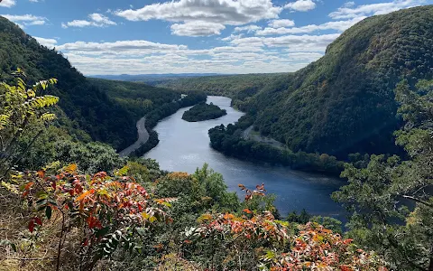
This
place
is
such
a
beautiful
hike
with
a
jaw
dropping
view
at
the
top!
The
first
half
going
up
red
dot
is
a
fairly
steep
climb,
so
be
prepared
to
work
those
calf
muscles!
Blue
blaze
down
is
simpler,
but
steep
at
some
points.
When
entering
the
lot,
you
can
go
up
Red
Trail
or
Blue
Trail.
Blue
trail
has
multiple
water
features
and
will
bring
you
peace
and
relaxation.
It
is
recommended
to
go
up
red
and
down
blue,
but
if
you
can't
fair
steep
climbing,
up
blue
and
down
blue
will
be
your
route!
The
mountain
is
about
1200
foot
elevation
and
took
me
about
2.5
hrs
to
do
the
loop,
thats
with
stopping
for
the
view
and
spending
a
good
20
min
by
the
water
features!
Wear
proper
hiking
shoes,
bring
water
and
a
snack.
Also
-
earlier
the
better
because
the
limited
parking
lot
fills
fast
and
I
went
in
early
March!
Enjoy
nature's
beauty!
5 people found this review helpful 👍