5/5 Victor Garrido (. 3 years ago on Google
(Translated
by
Google)
We
climb
to
this
peak
by
the
natural
stairs
that
lead
to
Alhaurín
de
la
Torre.
The
path
at
the
beginning
is
quite
steep
and
not
suitable
for
people
who
have
vertigo,
but
without
a
doubt
when
you
reach
the
top
and
enjoy
the
views,
it
is
well
worth
all
the
effort.
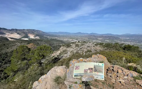
Right
at
the
peak
there
is
a
signage
area
where
it
explains
very
well
both
the
views
that
can
be
enjoyed
and
the
fauna
that
exists.
If
you
have
come
this
far,
do
not
hesitate
to
walk
a
little
further
and
reach
Pico
Paloma,
where
the
views
are
even
more
spectacular.
(Original)
Subimos
a
este
pico
por
las
escaleras
naturales
que
dan
hacia
Alhaurín
de
la
Torre.
El
sendero
al
principio
es
bastante
empinado
y
no
apto
para
las
personas
que
tienen
vértigo,
pero
sin
duda
al
llegar
arriba
y
disfrutar
las
vistas
merece
muchísimo
la
pena
todo
el
esfuerzo.
Justo
en
el
pico
tiene
una
zona
de
cartelería
donde
explica
muy
bien
tanto
las
vistas
que
se
pueden
disfrutar
como
la
fauna
que
hay.
Si
has
llegado
hasta
aquí
no
dudes
en
andar
un
poco
más
y
llegar
a
pico
Paloma,
donde
las
vistas
son
aún
más
espectaculares
9 people found this review helpful 👍