5/5 Anurag D. 3 years ago on Google
Periyar
National
Park
and
Wildlife
Sanctuary
(PNP)
is
a
protected
area
located
in
the
districts
of
Idukki
and
Pathanamthitta
in
Kerala,
India.
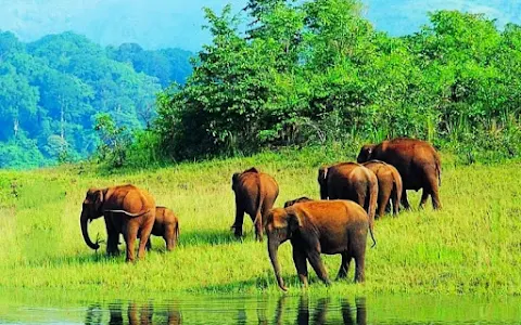
It
is
notable
as
an
elephant
reserve
and
a
tiger
reserve.
The
protected
area
encompasses
925
km2
(357
sq
mi)
of
which
305
km2
(118
sq
mi)
of
the
core
zone
was
declared
as
the
Periyar
National
Park
in
1982.
The
park
is
a
repository
of
rare,
endemic
and
endangered
flora
and
fauna
and
forms
the
major
watershed
of
two
important
rivers
of
Kerala,
the
Periyar
and
the
Pamba.
The
park
is
located
high
in
the
Cardamom
Hills
and
Pandalam
Hills
of
the
south
Western
Ghats
along
the
border
with
Tamil
Nadu.
It
is
4
km
(2.5
mi)
from
Kumily,
approximately
100
km
(62
mi)
east
of
Kottayam,
110
km
(68
mi)
west
of
Madurai
and
120
km
(75
mi)
southeast
of
Kochi.
History
Entrance
to
the
tiger
reserve
Periyar
Lake
The
first
official
action
towards
the
conservation
of
wildlife
and
biodiversity
in
Kerala
was
taken
in
1934
by
the
Maharaja
of
Travancore,
Chithira
Thirunal
Balarama
Varma,
by
declaring
the
forests
around
Periyar
lake
as
a
private
game
reserve
to
stop
the
encroachment
of
tea
plantations.
It
was
founded
as
Nellikkampatty
Game
Reserve.
It
was
consolidated
as
a
wildlife
sanctuary
in
1950
after
the
political
integration
of
India.
Geography
The
misty
mountain
ranges
of
the
Periyar
region
Periyar
National
Park
lies
in
the
middle
of
a
mountainous
area
of
the
Cardamom
Hills.
In
the
north
:
The
boundary
commences
from
the
point
nearest
to
the
Medaganam
in
the
interstate
boundary
up
to
Vellimalai.
and
the
east
Thence
the
boundary
follows
the
inter-state
boundary
from
Vellimalai
to
Kallimalai
Peak
(G.O.
(P)
No.65/2003/F&WLD
dated
Thiruvananthapuram,
20
December
03)
(1615
M)
it
is
bounded
by
mountain
ridges
of
over
1,700
m
(5,600
ft)
altitude
and
toward
the
west
it
expands
into
a
1,200
m
(3,900
ft)
high
plateau.
From
this
level
the
altitude
drops
steeply
to
the
deepest
point
of
the
reserve,
the
100
metre
valley
of
the
Pamba
River.
The
highest
peak
in
the
park
is
the
2,019
m
(6,624
ft)
high
Kottamala,
the
southernmost
peak
in
India
higher
than
2,000
metres
(6,562
ft).
The
Periyar
and
Pamba
Rivers
originate
in
the
forests
of
the
reserve.
The
other
prominent
peaks
within
the
park
are
Pachayarmala,
Vellimala,
Sunderamala,
Chokkampetti
mala
and
Karimala.
The
topography
consists
of
steep
and
rolling
hills
which
are
thickly
wooded.
The
sanctuary
surrounds
Periyar
Lake,
a
reservoir
measuring
26
km2
(10
sq
mi)
which
was
formed
when
the
Mullaperiyar
Dam
was
erected
in
1895.
The
reservoir
and
the
Periyar
River
meander
around
the
contours
of
the
wooded
hills,
providing
a
permanent
source
of
water
for
the
local
wildlife.
Climate
The
temperature
varies
depending
upon
the
altitude
and
it
ranges
between
15
°Celsius
in
December
and
January
and
31
°Celsius
in
April
and
May.
Annual
precipitation
is
between
2000
and
3000
mm,
about
two-thirds
occurring
during
the
southwest
monsoon
between
June
to
September.
Much
of
the
rest
occurs
during
the
northeast
monsoon
between
October
and
December.
Summers
are
warm
with
some
precipitation
in
April
and
winters
are
cold.
This
Park
is
Full
of
Natural
resources
and
Beauty
of
Mother
Natures
Creations.
Mother
Nature
is
Beautiful
🙏🏻🙏🏻🙏🏻
5 people found this review helpful 👍