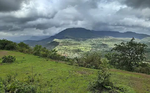
4/5 Girish S. 1 year ago on Google
Kalsubai
(Marathi:
कळसूबाई
शिखर)
is
a
mountain
in
the
Western
Ghats,
located
in
the
Indian
state
of
Maharashtra.
Its
summit,
situated
at
an
elevation
of
1,646
metres
(5,400
ft),
is
the
highest
point
in
Maharashtra.
The
mountain
range
lies
within
the
Kalsubai
Harishchandragad
Wildlife
Sanctuary.
It
is
visited
throughout
the
year
by
avid
trekkers,
Kalsubai
temple
devotees
and
wildlife
enthusiasts
alike.
It
is
named
after
one
of
the
three
sisters
Kalsubai,
Ratnabai
and
Katrabai.
The
other
peak
Ratangad
is
named
after
Ratnabai.The
peak
along
with
the
adjoining
hills
spans
along
a
downward-slanting
east
to
the
west
axis
eventually
merging
with
the
formidable
escarpment
of
the
Western
Ghats
at
almost
right
angles.
Along
its
length,
they
form
a
natural
boundary
demarcating
the
Igatpuri
Taluka,
Nashik
district
at
its
north
from
the
Akole
Taluka,
Ahmednagar
district
at
its
south.
The
mountain
itself
lies
on
the
Deccan
Plateau,
with
its
base
at
an
elevation
of
587
metres
(1,926
ft)
above
mean
sea
level.
The
mountain
along
with
adjoining
hills
forms
an
enormous
catchment
area
for
the
Arthur
Lake
which
it
overlooks.The
mountain
can
be
viewed
in
its
entirety
from
Bari
village
located
on
its
eastern
side,
about
six
km
(3.7
mi)
from
Bhandardara.
It
can
be
reached
by
road,
via
Igatpuri
on
the
Mumbai-Nasik
route.Trains
leaving
from
Mumbai
provide
an
alternate
mode
of
transport
to
Kasara
railway
station,
with
connecting
State
Transport
buses,
plying
on
the
Akole-Kasara
route,
leading
up
to
the
base
village.
Private
vehicles
from
Kasara
provide
yet
another
alternative
to
public
transport.Kalsubai
is
a
6.6
km-long
(4.1
mi)
trek
with
an
elevation
gain
of
around
2,700
feet
(820
m).
This
is
a
one-day
trek
having
a
moderately
hard
difficulty
level,
with
lush
green
landscapes
and
multiple
waterfalls.[5]
The
peak
attracts
many
trekkers
and
devotees
determined
to
scale
the
mountain.
To
reach
the
summit
there
are
well-designated
trekking
routes.
The
most
popular
route
is
through
the
eastern
mountain
face
taking
off
from
the
base
village
Bari.
The
krushnavanti
river,
a
tributary
of
Pravara,
takes
origin
on
its
eastern
slope
and
flows
like
a
stream
through
the
outer
fringes
of
Bari.
A
short
distance
away
from
the
stream
a
Hanuman
temple
has
been
built.
This
provides
an
important
landmark
to
commence
the
trek
as
well
as
a
resting
post
for
those
nearing
the
final
lap
of
their
trek.
The
route
from
behind
this
temple
takes
the
hiker
straight
to
the
summit.
The
trek
along
this
route
is
a
mix
of
easy
to
ascend
slopes
as
well
as
treacherous
rocky
outcrops
overlooking
the
valley
below.
Considering
the
increasing
footfall
in
recent
years,
the
government
has
built
iron
ladders
along
the
vertical
hill
slopes.
These
assist
trekkers
to
allow
for
a
convenient
and
safe
ascent.
The
route
via
Indore
is
relatively
unexplored
as
not
many
people
are
aware
of
it.
Unlike
the
regular
route
via
Bari,
which
has
fixed
ladders,
cemented
steps
and
several
people
flocking
during
the
monsoon,
the
route
via
Indore
is
raw
with
stone
steps
and
a
huge
iron
chain
for
support
at
the
dangerous
patches.