5/5 A Z. 1 year ago on Google
You
can
access
this
trailhead
by
going
down
about
a
mile
total
of
dirt
roads
from
the
main
street.
It
was
decently
smooth,
and
GPS
should
point
you
the
right
way.
There
was
also
a
sign
too
at
the
start
of
the
parking
lot.
It
was
a
roundabout
lot
where
you
come
in
one
way
and
can
park,
and
then
just
exit
the
other
way.
There
was
plenty
of
parking
and
there
were
still
a
few
spaces
to
park
even
on
a
weekend.
As
for
amenities,
there
were
2
pavilion-style
picnic
tables
and
there's
a
restroom-
only
toilets,
no
sink.
From
the
parking
lot,
you
should
see
the
Arizona
Trail
sign
and
then
you
can
walk
down
a
small
sandy
slope
across
what
appears
to
be
a
creek
bed
and
then
back
up.
From
there,
the
trail
branches
off.
If
you
go
left,
it's
a
gradual
gentle
uphill
climb
and
it
seems
to
end
at
a
fence.
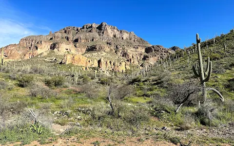
You
get
to
see
the
side
of
the
mountain
from
a
distance
and
you
see
the
green
trees
on
your
other
side.
If
you
go
right,
you
are
on
the
Arizona
Trail.
Walk
a
few
minutes
and
then
you
will
see
a
trail
cutting
off
to
the
left-
I
continued
on
that
cutaway
trail
which
is
a
one-way
climb
up.
It's
an
uphill
climb
(gradual)
but
this
one
takes
you
up
much
higher
and
closer
to
the
actual
mountain.
Only
towards
the
top,
there
was
one
small
part
with
a
few
feet
of
loose
gravel
but
other
than
that,
it
was
beginner
friendly.
The
birds-eye
view
you
get
is
amazing!
1 person found this review helpful 👍