Windy Hill Summit image

Windy Hill Summit

Vista point

One of the Best Places To Visits in Portola Valley


Address

Windy Hill Summit Trail, Portola Valley, CA 94028

Website

www.openspace.org

Contact

(650) 691-1200

Rating on Google Maps

4.90 (124 reviews)

Open on Google Maps

Working Hours

  • Friday: 7 AM to 7 PM
  • Saturday: 7 AM to 7 PM
  • Sunday: 7 AM to 7 PM
  • Monday: 7 AM to 7 PM
  • Tuesday: 7 AM to 7 PM
  • Wednesday: 7 AM to 7 PM
  • Thursday: 7 AM to 7 PM

Featured Reviews


Frequently mentioned in reviews: hike (10) summit (9) trail (8) sunset (7)
Reviews are sorted by relevance, prioritizing the most helpful and insightful feedback at the top for easier reference.
  • 5/5 Unforgettable D. 3 years ago on Google
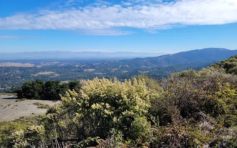
    Windy Hill Summit offers a sunset unlike any other in the Bay Area. Sitting high above the 1335-acre Windy Hill Open Space Preserve, Windy Hill offers sweeping views of the Santa Cruz mountains and Pacific ocean to the west, and the Bay Area to the East. The quickest way to reach the summit is via Anniversary Trail. This 1 mile loop trail is accessible via the Anniversary Trail Parking area along Skyline Blvd (California Hgwy 35). Looking for more adventure? Alternatively, you can reach the summit via a 7.5 mile hike from at the base of the preserve. This more strenuous hike is accessible from the parking area on Portola road, and features 1400 feet of elevation gain. If you do choose to visit Windy Hill for sunset, be aware that local wildlife, including mountain lions, become more active at dusk. Traveling in a group is typically the safest choice. Be sure to bring a blanket, a thermos of coffee, and some of your favorite snacks. Then, settle in for this remarkable sunset show.
    45 people found this review helpful 👍

  • 5/5 Tina N. 3 years ago on Google
    This is my favorite place to watch sunset, but I came up here on 8/19/2020, it is so sad, heartbreaking....
    6 people found this review helpful 👍

  • 5/5 Lei W. 3 years ago on Google
    Come in spring time. Two parking lots and a short loop trail. A glorious sight! And the roads leading here look magnificent too.
    4 people found this review helpful 👍

  • 5/5 Scott H. 5 years ago on Google
    The summit has some spectacular views of Silicon Valley and the peninsula. I highly recommend watching the sunset up here. The first time I visited we did the hike from the Alpine Trailhead, which was nice. However, I was pretty disappointed when I realize that you could also drive almost the entire way to the summit. :( On my second visit, I drove to the summit parking lot and walked the final 200 yards to the peak.
    4 people found this review helpful 👍

  • 5/5 Tabor G. 1 year ago on Google
    This is a great low effort high reward hike that is dog friendly. I would recommend the parking then hiking the anniversary trail and coming back via the lost trail along the road! Check out more travel ideas on @its.a.gamble on instagram.
    3 people found this review helpful 👍

  • 4/5 Negar A. 2 years ago on Google
    We tried the 9.9 miles hike and enjoyed it a lot. Its better to take your caps and sunglasses as well because it has sunny parts as well after passing the trees and going up high.
    2 people found this review helpful 👍

  • 5/5 Bachr C. 2 years ago on Google
    Nice view of the bay, exposed to the 🌞 so little bit 🥵

  • 5/5 Alex J. 4 years ago on Google
    Great place to go for a hike. Beautiful Views. Great for dogs. Hard to park if you go later, so plan to go early is the best. My only bad thing about the place is that there is no trash cans, so there is a lot of people that leaves doggie bags behind. In the summer be careful with rattle snakes.

  • 5/5 wei p. 5 years ago on Google
    Great view. It's a bit windy, so if you're planning to stay for a bit, make sure you bring a light jacket.

  • 5/5 Himani A. 3 years ago on Google
    We went to stargaze here right after sunset, it was beautiful.

  • 5/5 Dazhi W. 1 year ago on Google
    The drive up and down can be challenging. The short hike to the summit is not difficult but the trail is narrow. Bring a coat since it is windy up there even on a sunny day.

  • 5/5 Stephen L. 1 year ago on Google
    A short hike to the summit with beautiful 360° views of the bay and ocean.

  • 5/5 Ben H. 1 year ago on Google
    Perfect place for a nice view of Palo Alto and Stanford

  • 5/5 VINAY P. 1 year ago on Google
    Amazing trail, I tried the 2.4 miles trail which has 1235ft elevation. It was a great experience and a moderately challenging hike. The view on top is worth the effort and as the name goes it is super windy from the top. I would recommend sunglasses and water for the trail because half of the path is in shadow but the other half is exposed to the sun. It closes at 7pm so plan accordingly but the sunset views are amazing from the summit.

  • 5/5 William S. 1 year ago on Google
    There are serveral ways to get to this summit, I recommend starting from the ground as it’s more rewarding when you get to the top. I started from Portola Road and took Spring Ridge up and Hamms Gulch down. This hike mixes a nice in between of California redwoods and the costal plants as you start to get to the top. One of the best views is the valley.


Call (650) 691-1200 Open on Google Maps

Trends


Last updated:

Similar Vista points nearby

Last updated:
()