2/5 EE G. 4 months ago on Google • 228 reviews
New
Jersey
has
a
lot
of
excellent
hiking
spots.
It's
understandable
that
most
of
them
are
in
pretty
rural
areas
with
tons
of
room
to
roam/explore.
So
when
I
found
out
there
was
a
5.7-mile
hike
in
the
immediate
vicinity
of
Bridgewater/Somerville,
I
was
pretty
skeptical.
This
is
a
pretty
chaotic
section
of
the
state,
with
a
lot
of
major
highways
interconnecting
and
a
mall
and
heinous
traffic
circle
thrown
in
for
good
measure
-
it's
not
the
first
or
100th
place
I'd
think
of
for
a
hike.
That
remains
the
case.
You
can't
force
the
design
of
a
hike,
and
this
is
a
clear
example
of
a
situation
where
you
should
have
had,
say,
a
mile's
worth
of
trails
and
left
it
at
that.
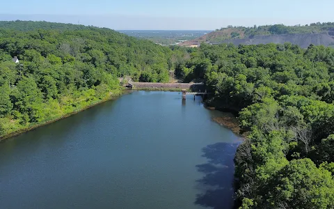
Our
trek
started
at
the
entrance/parking
lot
off
of
Newmans
Road
(spacious,
easy
to
spot
with
a
pretty
clean
port-a-potty;
there
were
drops
on
the
seat
but
that's
people
being
animals
and
not
a
reflection
on
the
park)
following
the
red
trail
running
roughly
parallel
to
the
Washington
Valley
Reservoir
before
crossing
Chimney
Rock
Road
and
heading
up
and
down
the
orange
trail
in
a
quasi
loop
that
runs
alongside
the
East
Branch
Reservoir
before
another
brief
foray
on
a
road
(this
one
Gilbride
Rd)
and
then
doing
another
loop
on
the
yellow
trail
that
goes
up
to
the
Chimney
Rock
Outlook
before
circling
back
to
Gilbride,
at
which
point
you
basically
complete
the
prior
orange
loop
and
then
head
back
on
the
other
side
of
the
Washington
Valley
Reservoir
to
the
parking
lot.
If
that
sounds
overly
complicated,
you're
right.
There
are
two
huge
issues
that
mar
this
hike
for
me.
One
is
that
whoever
designed
the
trails/blazes
for
this
place
had
no
idea
what
they
were
doing.
Literally
every
possible
trail
and
offshoot
is
painted
with
a
blaze,
always
the
same
color
as
the
"main"
trail.
As
such,
it's
incredibly
difficult
to
follow
an
official
hiking
itinerary
because
every
fork
in
the
trail
has
two
choices
with
the
same
color
blaze.
Incredibly
foolish
and
short-sighted.
We
had
to
VERY
carefully
stop
each
time,
look
at
the
map
in
our
book
AND
double-check
the
GPS/map
on
the
AllTrails
app
(which
I
hate
doing)
just
to
make
sure
we
were
on
the
right
path.
There's
no
reason
to
put
a
blaze
on
literally
any
walkable
route
like
that;
no
idea
what
they
were
thinking.
The
other
problem
is
what
I
alluded
to
earlier
-
this
is
a
populated
area
with
minimal
room
to
hike
so
you
end
up
by
definition
having
to
cross
and
briefly
walk
alongside
busy
roads.
Chimney
Rock
was
incredibly
busy
midday
on
Saturday,
and
cars
were
whizzing
by
us
the
entire
time
(the
first
section
was
probably
about
two
minutes
long,
while
the
second
was
five
minutes
-
believe
me,
it
felt
longer).
I'm
stunned
people
don't
get
hit
there,
especially
since
there's
not
a
lot
of
room
off
to
the
side
for
pedestrians.
If
you're
at
the
point
where
you're
brainstorming
a
hiking
trail
and
you
can't
avoid
having
the
hikers
come
into
contact
with
moving
vehicles,
that's
probably
a
clue
to
scrap
the
plans.
The
big
selling
point
of
this
hike
is
Chimney
Rock,
which
was
apparently
a
lookout
point
for
George
Washington
during
the
Revolutionary
War.
That's
all
well
and
good,
but
for
the
money
they
spent
to
put
up
a
protective
fence
and
pave
the
trail
here,
they
couldn't
be
bothered
to
maintain
the
actual
rock,
which
is
covered
by
broken
beer
bottle
glass.
And
I'm
sure
General
Washington
had
a
much
prettier
view
back
in
the
day
than
we
did;
we
were
treated
to
the
gorgeous
scenery
of
the
Stavola
Bound
Brook
Quarry
-
crushed
stones
as
far
as
the
eye
can
see!
The
best
part
of
the
hike
by
far
was
the
last
section
on
the
northern
side
of
the
Washington
Valley
Reservoir,
and
this
is
the
part
I'd
actually
preserve
for
walking,
etc.
It
definitely
helped
that
the
sun
was
out
at
this
point,
but
there
was
a
cute
bridge
and
a
lot
of
bird
activity.
We
also
encountered
a
fallen
tree
(picture
attached)
that
was
taken
down
by
a
beaver.
Very
cool
sighting.
Head
over
to
Watchung
Reservation
if
you're
in
the
area
and
want
to
commune
with
nature.
You
may
hear
the
sounds
of
Route
78
but
at
least
you
won't
be
crossing
that
highway
as
part
of
your
hike.
1 person found this review helpful 👍