Madrone Trail image

Madrone Trail

Tourist attraction Hiking area

👍 Nicely maintained trail with a lot of off shoots to make it as long or short as you’d like…only draw back is they aren’t all marked so make sure you have a GPS. Definitely bring sunscreen and bug spray. No fees to enter for the trail but you can’t access the beach area unless you pay. Bring good sho... People often mention trail, trails, lake, area, marked, nice, views, good, hiking,


Address

Canyon Park Rd, Canyon Lake, TX 78133, United States

Contact

+1 830-964-3341

Rating on Google Maps

4.40 (287 reviews)

Open on Google Maps

Featured Reviews


Frequently mentioned in reviews: trail (31) trails (11) lake (10) area (9) marked (7) nice (7) views (7) good (6) hiking (6)
Reviews are sorted by relevance, prioritizing the most helpful and insightful feedback at the top for easier reference.
  • 4/5 Sabrina K. 1 year ago on Google
    Nicely maintained trail with a lot of off shoots to make it as long or short as you’d like…only draw back is they aren’t all marked so make sure you have a GPS. Definitely bring sunscreen and bug spray. No fees to enter for the trail but you can’t access the beach area unless you pay. Bring good shoes as there is some climbing and rocky areas.
    10 people found this review helpful 👍

  • 5/5 Lissa M. 2 years ago on Google
    I didn't know about this place until just recently. The trails are pretty good I think I accidentally went on a bike trail but it was really nice. Near the lake It is very peaceful.
    5 people found this review helpful 👍

  • 5/5 mason l. 1 year ago on Google
    First time riding at Madrone Trail. Fun, challenging, and great views!
    5 people found this review helpful 👍

  • 4/5 Rick F. 2 years ago on Google
    Several parts of the Madrone Trail are like the Rocky Raccoon Trail in McAllister Park in San Antonio, and sometimes harder than that trail. It was a nice windy day when I rode here. There were several view spots of Canyon Lake. The signage is terrible, so you may want to use a trail map application while riding. Overall, it was a nice ride. I gave it a 4 because there were parts of the trail that I had to walk my bike over some rocky parts.
    4 people found this review helpful 👍

  • 5/5 A F. 2 years ago on Google
    Great hike! Rocky terrain but not too difficult to navigate. Take a picture of the map before you jump on a trail for reference.
    4 people found this review helpful 👍

  • 5/5 Lori N. 2 years ago on Google
    This is a wonderful 7.5 mile trail system on the shores of Canyon Lake. Bring water with you as you can easily spend hours here exploring. There’s no lake access from any of the trails, just awesome views.
    4 people found this review helpful 👍

  • 4/5 Richard B. 3 years ago on Google
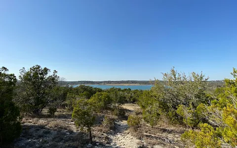
    Rugged, primative, & beautiful, shaded by the juniper trees and multiple vantage points of the lake as you bike/hike the penensuila. Bring a picnic lunch there's TONS of concrete picnic tables along the route. Lots of exposed limestone and tree roots on the trail to trip you up, and slow you down to navigate your way through. You wind your way past what looked like a long abandoned section of campground after a fire looked like it had burned through the area, criss-crossing old boat ramps sprouting grass, bathrooms that stand unused, even drinking fountains and trash can holders. Then you pass into the current but also unused part (COVID) of the campground as your returning back towards the trailhead now on the opposite side of the penensuila and are treated to new tree breaks that offer up a different view side of the lake.The trail was a bit confusing to find at the trail head and GPS came in very handy, once on the trail it is well marked most of the way and pink ribbons tied to the trees provided a visual to mark the way in questionable spots. This trail needs some branches, roots, and rocks removed if and when people start getting back out and about, but very sparsely traveled on a weekday during COVID while I was out there and made it quick to knock out the loop in a couple hours.
    4 people found this review helpful 👍

  • 5/5 Stefan V. 2 years ago on Google
    Excellent trail for hiking and mountain biking. Mostly shaded. Good elevation changes, plenty of advanced features for bikers, several small and medium drops, challenging rock gardens and technical climbs. Definitely will give a great workout. Beginners can ride many parts but will need to walk quite a few sections. Nice views of the lake, low traffic even on a busy Sunday. Highly recommend!
    3 people found this review helpful 👍

  • 4/5 Joe S. 3 years ago on Google
    Beautiful views with some rough ground walking. Some steep incline areas, but overall a good trail for mountain bikes and hikers. It is easy to get lost due to missing trail markers and lots of intersections. Best to use a trail mapping app or other GPS to stay on track.
    3 people found this review helpful 👍

  • 5/5 Mallory D. 1 year ago on Google
    Very well maintained, although not well marked trail! I love this area because most of the time you will be out all by yourself! Mountain biking is rough due to all the rocks... but for trail running and hiking this is an awesome Hill Country spot!
    3 people found this review helpful 👍

  • 5/5 Stephen K. 11 months ago on Google
    Great trails. Hardly anyone out there. Beautiful woods. Rocky and sometimes muddy trails. But nothing serious. Plenty of shade.
    2 people found this review helpful 👍

  • 5/5 Roland R. 1 year ago on Google
    Great hiking experience here. Hiking and mountain biking are allowed in the trails. The different terrains throughout prove to be a great workout as well.
    2 people found this review helpful 👍

  • 5/5 Ezra L. 9 months ago on Google
    Nice short but challenging mtb trail. Nothing too crazy just lots of rock gardens. Awesome place to visit…. In the fall or spring. 😊
    1 person found this review helpful 👍

  • 5/5 A G. 9 months ago on Google
    I very nice hike at Canyon Lake. Full trail is about 8 miles. Parts of it go through the area of the park that used to have picnic and camping areas but is now overgrown and closed. Volunteers are creating a pollinator area where butterflies can be seen in the fall. Only downside is summer heat in Texas continues to get worse every year making outdoor hikes more difficult.
    1 person found this review helpful 👍

  • 5/5 Thilak D. 8 months ago on Google
    The area is a large group of smaller trails. There is one trail that leads you directly to a side of the lake that is empty, where you can just sit and enjoy the view. I ended up getting lost and walking around for a few hours. This place is awesome. The entrance is located about a half mile before the pay-to-enter area.
    1 person found this review helpful 👍

  • 3/5 Glenn P. 1 year ago on Google
    nice trails but very poorly marked. If you're not familiar you will get lost. Fortunately it's not a very big area and you'll come out somewhere...but a map/GPS/Phone should be mandatory.
    1 person found this review helpful 👍

  • 5/5 Sally S. 1 year ago on Google
    I recently hiked here and really enjoyed it. I just wish there were a few more markers on the trail. Beautiful views of the lake!
    1 person found this review helpful 👍

  • 3/5 Wendi the W. 11 months ago on Google
    Enjoyed the trail that had good views of the lake. The trail is not well marked and the restrooms are not well maintained so plan accordingly.

  • 4/5 Phil S. 1 year ago on Google
    Lots of hiking with plenty of lake views. We only ran across one other hiker on a Monday in the off-season. The only negative is that these trails are poorly marked so you must use your phone and the lake as your guide.

  • 5/5 Tom C. 2 years ago on Google
    Really nice trail system which is good for hiking or mountain biking. Moderate difficulty through most of the trails with some technical areas. There is not a great deal of elevation change, but there are some rocky drop-offs and climbs. None are very long though. Overall, a really nice area for hiking or biking. Bring water as there isn't drinking water available there. Cheers!

  • 4/5 Stephanie 7 months ago on Google
    Came here on a Friday around 2pm and it was not busy at all. They have a separate parking lot with a restroom plus it’s free & they allow dogs ☺️ The only thing I did NOT like was that the trails were not clearly marked. Some of the trails would split off and you just have to guess and pick a way. I would just make sure you come prepared and bring lots of water… just in case!

  • 5/5 Bill N. 2 years ago on Google
    Part of the 7.5 mile trail has a fee but you can walk the first two miles or so for free then there is a trail marker with a path back to the trail head. Walked that section. Very rocky in spots with lots of sections with loose rocks. Walked it in low cut trail shoes but something with ankle support would have been better. A few places sometimes hard to tell which way trail goes, alltrails.com map very good.


Call +1 830-964-3341 Open on Google Maps

Amenities


  • Pets
    • ✓️ Dogs allowed
    • ✓️ Dogs allowed outside
  • Activities
    • ✓️ Hiking

Trends


Last updated:

Similar Tourist attractions nearby

Last updated:
()