Featured Reviews


Frequently mentioned in reviews: peak (7) view (6)
Reviews are sorted by relevance, prioritizing the most helpful and insightful feedback at the top for easier reference.
  • 5/5 Milinda H. 2 years ago on Google
    AbsolutelyBeautiful place. Also well known for camping. When you camp there remember to take back your garbage. We collected more than 10kg of plastics and beer cans that left by the so called camping nature lovers. Don't ruin this beautiful environment.
    16 people found this review helpful πŸ‘

  • 4/5 Sky for Y. 7 months ago on Google
    A great place for your hike and camping experience. For the peak rock it will take about 45mins to reach. To the top it will take around 1 - 2hrs. The view and the top experience was fabulous. If you look around you can see several places like amubuluwawa tower from the peak. And its very quite and calm hike.❀️
    10 people found this review helpful πŸ‘

  • 5/5 Harshan p. 1 year ago on Google
    A mountain top with a very beautiful view, but it is difficult to find water at the top.... so it is advisable to carry water. Within the Dolosbage mountain range, Kabaragala Mountain is a fantastic and easy climb. The summit, which offers a completely different experience, can be reached by traveling along the ridge from the first viewpoint. It has an almost flat terrain covered with grass; which reminds the unique landscapes of Horton plains. Nawalapitiya town, Gampola & Ambuluwawa, Alagalla, Peacock hills, Bathalegala & Kotmale maha seya, Piduruthalagala range, the reservoir and the rest of Dolosbage mountain range are also visualized from the top. In the morning, you can see a beautiful sunrise.
    3 people found this review helpful πŸ‘

  • 5/5 Janidu V. 1 year ago on Google
    Easy hike. Do take enough water as there is no water on top. For people travelling from colombo and want to do a one day trip ; take the 5:55 badulla train, get down in nawalapitiya or gampola. Take the dolosbage bus, get diwn near kabaragala trail start(tell the conductor). The hike to the 1st view point will take around 1hr and the hike to the 2nd view point is about another 50mins. U can come back down to the road around 3.30 - 4.00 and there is a bus back to nawalapitiya around 4.15. You can catch the 5.00 train back to colombo which comes to colombo at 10.00 Safe travels and please make sure to keep the environment clean πŸ™πŸΌ 😊
    3 people found this review helpful πŸ‘

  • 5/5 Tharindu R. 7 months ago on Google
    Cannot describe the beauty of this place in words. ❀️ Very beautiful view and misty atmosphere. If it rains the peak and the path will be very slippery. So please be carefull. And be prepared for leech attacks. So many leeches 😐 I heard there are one or two paths more to reach the peak. We took the one began from the temple below. If you park your vehicle there you should inform the monks.
    2 people found this review helpful πŸ‘

  • 5/5 Ravindu L. 9 months ago on Google
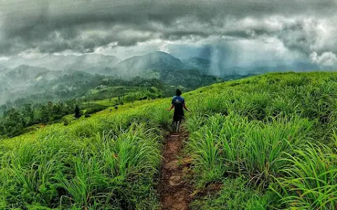
    #Kabaragala is the highest peak in the Dolosbage Mountain Range in Sri Lanka. This is located on the border between the districts of Kagalle and Kandy. The height of the peak is 1506 m above sea level. The place is superb for hikers and campers. #About 1- 1.5 Hour Hike. #Amazing View on Top. #Dangerous Cliffs. ⚠️ #All Bikers, Motor cars , Jeeps , Vans Can Only use Dedugala - Dolosbage Road. ( Very Narrow Roads and over 100 Super Bends are Available βš οΈβ—οΈ) #Buses and Others can reach From Nawalapitiya and then to Kabaragala. About 12km. #Attached bus 🚌 bend videos, we came from dedugala - Dolosbage Road. Really very Hard to get 54 seater from that road ultimately we did it after lot of effort. #Thank You ! πŸ”₯🫢🏻
    1 person found this review helpful πŸ‘

  • 1/5 albert s. 1 year ago on Google
    Worst trekking experience I had. Literally zero safety throughout the trek. I saw many people crying while coming down, many fell down and many couldn’t complete the trek they left in middle of the trek. Highly not recommended for first time trekkers and those who are above 100kgs. BTW there is no hearten shaped lake there, seems it was man made lake above the peak.

  • 4/5 Raj M. 1 year ago on Google
    It’s near the Nawalapitiya. The road is not good from Nawalapitiya to kabaragala. Difficult to drive a car. Parking available in under the mountains. 3,4 km hiking. One shop available in around 1,2km. It has small food packets, Rotti, sambol,water bottle, and others food’s & drinks. They are renting Camping item. Top views are amazing. 360 view. Difficult to use drones because of heavy wind. Risky place. Best place for camping. Not shootable for families and senior citizens.


Open on Google Maps

Amenities


  • Pets
    • βœ“οΈ Dogs allowed
  • Activities
    • βœ“οΈ Hiking
  • Accessibility
    • βœ— Wheelchair-accessible car park
    • βœ— Wheelchair-accessible entrance


Similar Hiking areas nearby

Last updated:
()