4/5 Tomita H. 2 years ago on Google
(Translated
by
Google)
2022/3/11
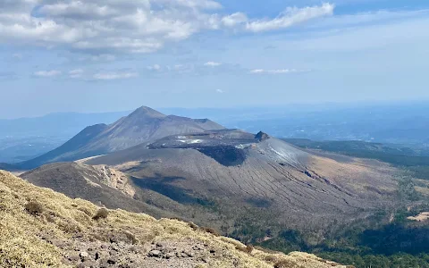
Altitude
1,700m.
One
of
Japan's
100
Famous
Mountains.
Mt.
Karakunidake,
the
highest
peak
of
the
Kirishima
mountain
range,
the
source
of
energy
for
the
people
of
Kagoshima
and
Miyazaki
prefectures.
It
is
sometimes
written
as
Mt.
Karakuni,
and
it
seems
that
the
Shimazu
clan,
who
was
a
feudal
lord
in
the
Edo
period,
often
visited
the
mountain.
The
weather
was
not
so
good
today,
but
I
climbed
from
Mt.
Karakuni-dake
trailhead
in
Ebino
Kogen.
I
will
attach
the
photos
in
order.
This
course
is
the
shortest,
taking
1
hour
and
40
minutes
to
reach
the
summit
and
1
hour
and
20
minutes
to
return.
Climbing
equipment
required.
There
are
no
chains,
steep
climbs,
or
dangerous
spots,
but
please
be
careful
not
to
get
too
close
to
the
summit
or
the
eastern
side
of
the
rocky
ridge
leading
to
the
summit,
as
there
is
a
cliff
(crater).
Also,
when
descending,
there
is
a
branch
that
is
difficult
to
understand
from
the
trace
just
below
the
summit,
and
it
is
easy
to
accidentally
go
straight
towards
Onami
Pond,
so
please
follow
the
sign
and
go
to
the
right
(towards
the
crater
ridge).
Today,
the
summit
was
foggy
and
there
was
no
view,
but
on
the
way,
I
could
see
Mt.
Ebino
Kogen
No.
1
parking
lot
(500
yen,
with
toilet
and
shoe
washing
area)
is
located
near
the
trailhead.
Have
a
nice
climb
everyone!
(Original)
2022/3/11
標高1,700m。日本百名山の一座。鹿児島県そして宮崎県の方々のエネルギーの源、心の山である霧島連峰の最高峰、韓国岳(カラクニダケ)。唐国岳と表記される事もあり、江戸時代には領主であった島津氏も度々登山に訪れた様です。本日天気はあまり良くありませんでしたが、えびの高原にある韓国岳登山口より登山をさせて頂きました。順に写真を添付致します。このコースは最短コースで、山頂迄コースタイム1時間40分、帰りは1時間20分です。登山装備必要です。鎖場、急登箇所、危険箇所は有りませんが、山頂や山頂へつながる岩稜の東側は崖(火口)となっていますので近づきすぎないように十分注意して下さい。また、下山時、山頂直下にトレースからは分かりづらい分岐があり、うっかり直進ぎみの大浪池方面へ行きがちですので、看板に従い右方向(火口の尾根方向)へ行ってください。本日山頂部は霧で眺望はありませんでしたが、道中、硫黄山や勢いよく噴き上がる噴煙を望め、火の国九州を堪能することが出来ました。登山口間近にえびの高原第一駐車場(500円、トイレと靴洗い場有り)があります。それでは皆様よい登山を!
27 people found this review helpful 👍