5/5 DAMITH C. 2 years ago on Google
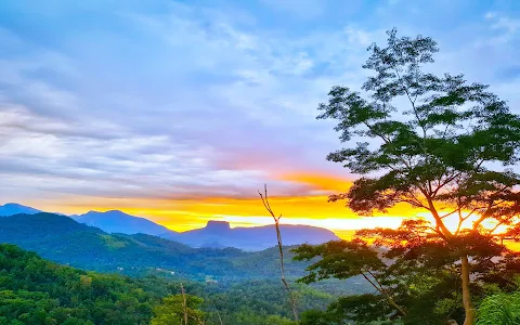
When
you
travel
along
Kandy
road
passing
Kadugannawa
area,
look
across
the
valley
to
witness
a
peculiar
shaped
rock
at
the
distance.
The
shape
reminds
you
of
the
famous
rock
fortress
Sigiriya
but
it
is
in
fact
“Bathalegala”
or
“Bible
Rock”
as
the
British
named
it.
As
a
child,
It
confused
me
enough
to
think
it
was
Sigiriya
until
someone
was
kind
enough
to
correct
me.
By
the
look
of
it,
seems
like
it
is
a
tough
climb
right?
But
the
looks
indeed
can
be
deceiving.
Read
along
to
find
out.
About
the
rock
The
height
of
the
rock
is
stated
as
797.7
m
in
the
survey
map.
The
breadth
spans
a
whopping
710
m
across
the
rock
surface.
The
surface
is
mostly
flat
covered
in
mana
and
some
woods
here
and
there.
If
you
are
starting
from
the
trailhead,
the
elevation
gain
would
be
around
150m.
You
can
also
start
the
hike
from
Hathgampola
town.
In
that
case,
the
elevation
gain
would
be
around
500m.
How
to
get
there?
Bathalegala
is
located
close
to
Aranayake.
Whether
you’re
coming
from
Colombo
or
Kandy,
turn
onto
Aranayake
road
at
Mawanella.
Follow
the
road
until
Gevilipitiya,
turn
right
at
the
junction
and
drive
about
2km
to
Hathgampola
town.
From
there
you’ll
have
to
turn
right
to
a
narrow
road
(Bathalegala
road)
with
a
signboard
“to
the
Bathalegala
road”
Following
this
road,
you’ll
reach
a
junction
where
you
should
turn
left
to
a
narrower
road
which
runs
past
the
trailhead.
After
driving
2.5
km
on
this
road,
look
towards
your
right
to
notice
the
starting
point.
There
is
a
signpost
so
it
is
hard
to
miss.
Parking
space
is
available
but
limited.
21 people found this review helpful 👍