5/5 Muhammad Abu Bakar S. 3 years ago on Google
Gypsy.travel

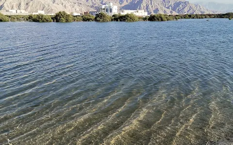
Saraya
Island
is
the
unique
landscape
of
sea
with
the
background
view
of
Hajar
mountains.
The
island
is
the
turquoise
waters
of
the
bay
located
few
kilometres
away
from
Ras
Al
Khaimah
“TURQUOISE
WATERS
OF
THE
BAY”
In
the
past
the
saraya
Island
was
created
for
development
hotels,
villas,
shopping
centers,
restaurants,
and
entertainments
etc.,.
The
project
was
suspended
and
there
have
been
no
updates
on
construction
plans
since
2009.
Now,
the
island
has
become
a
paradise
for
campers.

You
follow
the
coordinates
(25°53’09.1″N
56°00’57.1″E)
to
reach
the
entrance
to
saraya
island
which
takes
you
to
a
bridge
at
the
north
end
of
Al
Rams,
RAK.
Before
the
bridge
you
will
see
the
warning
sign
board
stating
it’s
military
base
camp
and
not
to
park
the
car
&
take
photos
/
videos
from
the
bridge.
After
you
cross
the
bridge
you
keep
the
left
side
track
and
on
the
right
side
you
will
have
an
open
sea
along
with
more
tracks
to
follow.
Continue
to
the
left
side
which
is
easy
to
travel
with
a
sedan
upto
certain
limit
and
you
can
park
your
car
then
take
a
small
walk
to
make
your
own
tent
in
front
of
the
secret
beach.
You
will
find
horses
and
camels
farm
alongside
the
drive
(right
side).
Please
be
cautious
that
some
of
the
terrains
are
wetland
especially
close
to
lake
views
(left
side)
and
your
car
may
get
stuck.
During
weekends,
the
Island
is
usually
busy
and
noisy
with
people
having
fun
with
their
off-road
vehicles
and
buggies
even
during
the
night
times.

I
didn’t
take
more
pictures
to
give
you
the
feel
of
the
location
and
lakeside
villa
views
which
is
mesmerizing.
But
one
thing
I
can
tell
you
is
that
Saraya
Island
will
give
you
an
international
camping
experience.
Coordinates:
25°53’09.1″N
56°00’57.1″E
(starting
point)
10 people found this review helpful 👍