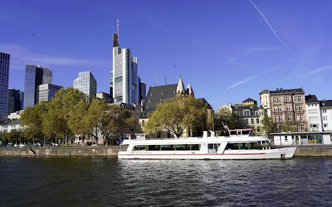
4/5 martin d. 5 years ago on Google
(Translated
by
Google)
Living
and
living
by
the
river
-
this
dream
has
come
true
in
Frankfurt
thanks
to
the
Mainuferpark.
True
to
its
name
"Frankfurt
am
Main",
the
city
wanted
to
design
the
Main,
its
banks
and
the
adjacent
areas
as
a
central
public
open
space.
In
1986
she
announced
a
competition
for
the
landscape
and
urban
development
of
the
Main
riverbank.
From
1990
the
Consilium
Stadtraum
Main
pushed
the
project
of
a
Mainuferpark
between
Deutschherrnbrücke
in
the
east
and
Main-Neckar-Brücke
in
the
west.
By
2006,
just
in
time
for
the
World
Cup,
a
park
landscape
of
around
seven
kilometers
was
created
on
both
banks
of
the
river.
Such
a
symbiosis
of
river,
bank
and
city
silhouette
is
unique
in
this
form
in
Germany.
A
touch
of
the
Mediterranean
Plane
trees
delimit
and
shape
the
Mainuferpark
on
the
so-called
northern
"Frankfurt"
side,
the
continuous
riverside
path
and
the
bridge
contours
are
illuminated
at
night.
At
the
Westhafen
the
park
begins
with
a
glamorous
"Little
Venice"
built
on
the
pier
and
characterized
by
the
99
meter
high
"Westhafen
Tower".
Sunbathing
lawns
invite
you
to
relax
along
the
Untermainkai.
In
Nice,
walkers
experience
a
touch
of
the
Mediterranean
with
palm
trees
and
southern
plants.
Just
a
few
steps
from
the
Römer,
the
Eiserne
Steg
"dribb
de
Bach"
(Frankfurt
for
"over
the
Main
to
the
south
bank")
leads
along
the
old
town
center,
excursion
boats
and
a
historic
railway
set
off.
The
green
strip
widens
at
the
Schöne
Aussicht
and
beyond
the
Flößerbrücke
the
"somewhat
different"
green
area
of
the
Weseler
Werft
connects
the
newly
built
residential
area
in
Ostend
with
the
Main.
It
ends
at
the
bastions
of
the
Ruhrort
shipyard,
in
front
of
the
old
wholesale
market
hall,
where
the
European
Central
Bank
will
reside
in
the
future.
Relax
and
celebrate
Over
the
water,
the
view
goes
from
here
into
the
green:
living
and
living
by
the
river
is
the
motto
there
too,
on
the
Deutschherrnufer
with
its
Mediterranean
flair.
To
the
east,
the
Mainwasen
join
in
the
direction
of
the
Gerbermühle.
The
Museumsufer
stretches
to
the
west
with
top-class
museums
on
the
Schaumainkai
and
the
green
Tiefkai
-
a
year-round
meeting
point
for
relaxation,
flea
markets,
Main
Games,
the
Night
of
Museums
and
the
Museum
Embankment
Festival.
Beyond
the
Friedensbrücke,
the
Theodor-Stern-Kai
offers
real
new
territory:
17
m
wide
and
800
m
long
it
was
separated
from
the
Main
riverbed
and
designed
as
a
park.
On
the
Sachsenhausen
side,
the
promenade
of
the
Mainuferpark
connects
the
national
cycle
path
from
east
to
west.
(Original)
Wohnen
und
Leben
am
Fluss
-
durch
den
Mainuferpark
ist
dieser
Traum
in
Frankfurt
wahr
geworden.
Getreu
ihrem
Namen
"Frankfurt
am
Main"
wollte
die
Stadt
den
Main,
seine
Ufer
und
die
angrenzenden
Flächen
als
zentralen
öffentlichen
Freiraum
gestalten.
1986
schrieb
sie
einen
Wettbewerb
für
die
landschaftliche
und
städtebauliche
Entwicklung
des
Mainufers
aus.
Ab
1990
forcierte
das
Consilium
Stadtraum
Main
das
Projekt
eines
Mainuferparks
zwischen
Deutschherrnbrücke
im
Osten
und
Main-Neckar-Brücke
im
Westen.
Bis
2006,
pünktlich
zur
Fußball-WM,
entstand
an
beiden
Flussufern
eine
Parklandschaft
von
rund
sieben
Kilometern
Länge.
Eine
solche
Symbiose
von
Fluss,
Ufer
und
Stadtsilhouette
ist
in
dieser
Form
in
Deutschland
einmalig.
Ein
Hauch
vom
Mittelmeer
Platanen
begrenzen
und
prägen
den
Mainuferpark
auf
der
sogenannten
nördlichen
„Frankfurter“
Seite,
der
durchgehende
Uferweg
und
die
Brückenkonturen
sind
nachts
illuminiert.
Am
Westhafen
beginnt
der
Park
mit
einem
mondänen
"Klein-Venedig"
errichtet
auf
den
Hafenmolen
und
geprägt
vom
99
Meter
hohen
"Westhafen-Tower".
Liegewiesen
laden
entlang
dem
Untermainkai
zum
Entspannen
ein.
Im
Nizza
erleben
Spaziergänger
einen
Hauch
von
Mittelmeer
mit
Palmen
und
südländischen
Pflanzen.
Entlang
des
alten
Stadtkerns
führt
am
Mainkai
nur
wenige
Schritte
vom
Römer
der
Eiserne
Steg
"dribb
de
Bach"
(frankfurterisch
für
„über
den
Main
ans
Südufer“),
starten
Ausflugsschiffe
und
eine
historische
Eisenbahn.
Der
Grünstreifen
verbreitert
sich
an
der
Schönen
Aussicht
und
jenseits
der
Flößerbrücke
verbindet
die
"etwas
andere"
Grünanlage
der
Weseler
Werft
das
neuerbaute
Wohnquartier
im
Ostend
mit
dem
Main.
Sie
endet
an
den
Bastionen
der
Ruhrorter
Werft,
vor
der
alten
Großmarkthalle,
wo
zukünftig
die
Europäische
Zentralbank
residieren
wird.
Entspannen
und
Feiern
Über
das
Wasser
geht
der
Blick
von
hier
ins
Grüne:
Wohnen
und
Leben
am
Fluss
heißt
die
Devise
auch
dort,
am
Deutschherrnufer
mit
seinem
mediterranen
Flair.
Nach
Osten
schließen
die
Mainwasen
in
Richtung
Gerbermühle
an.
Westlich
erstreckt
sich
das
Museumsufer
mit
hochkarätigen
Museen
am
Schaumainkai
und
dem
grünen
Tiefkai
-
Treffpunkt
rund
ums
Jahr
zum
Entspannen,
für
Flohmarkt,
Mainspiele,
Nacht
der
Museen
und
Museumsuferfest.
Jenseits
der
Friedensbrücke
bietet
der
Theodor-Stern-Kai
echtes
Neuland:
17
m
breit
und
800
m
lang
wurde
er
vom
Mainbett
abgetrennt
und
als
Park
gestaltet.
Auf
der
Sachsenhäuser
Seite
verbindet
die
Promenade
des
Mainuferparks
den
überregionalen
Radwanderweg
von
Ost
nach
West.
1 person found this review helpful 👍