4/5 Wanderlust W. 1 year ago on Google • 342 reviews
Accessibility
Entrance
point
1(towards
the
water
tank)
A
bit
tricky
if
you
take
the
grab,the
starting
point
towards
the
water
tank
is
in
the
middle
of
a
busy
road.
Entrance
point
2
(passes
through
the
Harvest
Group
and
the
residential
area)
You
could
see
some
stairs
leads
to
the
trail.
Starting
point
as
most
of
the
people
walking
towards
the
water
tank.After
passing
2
watertanks,you
will
see
a
split
at
the
2nd
water
tank,take
the
left
one.
Follow
the
path
which
leads
to
the
top,there
are
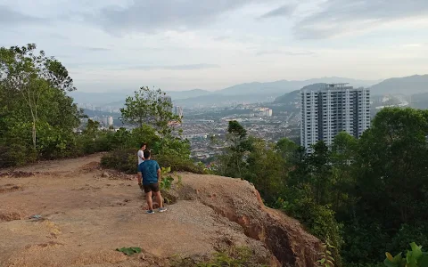
several
viewpoints
after
10-15
mins.Then
just
look
up
for
a
tent,arriving
the
tent,takes
the
left
one
and
go
all
the
way
up.Then
you
look
for
the
communication
tower
which
leads
you
to
the
peak.
After
the
communication
tower,the
easier
way
is
to
go
back
the
original
trail
and
down
to
the
entrance.
If
you
keep
walking
alo
g
the
gate
of
the
tower,you
will
see
a
path
go
downwards.
You
could
go
down
from
there
as
well
but
the
path
is
not
in
a
good
condition
especially
after
raining.A
bit
slippery
and
muddy.Actuall
the
way
down
on
this
path
is
longer
than
the
original
one.
As
you
keep
going
down
this
path,you
will
see
a
sign
which
leads
you
to
the
mini
waterfall.
Once
you
reach
a
split,you
will
cross
a
little
stream
and
then
you
will
see
an
arrow
on
the
tree
and
ropes,take
the
path
with
ropes
going
up
and
you
will
see
the
mini
waterfall,and
you
could
wash
your
hands
and
get
a
splash
of
fresh
water
to
cool
down
your
body.
Passing
through
the
mini
waterfall,you
will
see
another
tent
and
takes
the
left
path
which
go
all
the
ways
down
to
the
residential
area.
5 people found this review helpful 👍