4/5 Daisei Iketani (. 3 years ago on Google
The
climb
up
Mt.
Kintoki
(金時山
Kintokiyama),
which
also
goes
by
the
name
of
Mt.
Ashigara
(足柄山
Ashigarasyama)
for
some
reason
I
have
yet
to
understand.
Google
Maps
show
the
name
of
Ashigara,
but
when
you
reach
the
peak,
the
sign
says
Kintokiyama.
A
bit
confusing
to
say
the
least.
At
the
trailhead,
there
is
a
nice
parking
lot
with
an
even
nicer
restroom
with
faucets
outside
that
you
can
use
to
wash
your
boots
when
you
come
back
down
the
mountain.
There
were
only
about
8
parking
spaces
(free),
so
you
need
to
arrive
early
enough
in
the
morning
to
catch
a
space.
The
mountain
is
not
that
high
at
only
1,212
m
(3,976
ft).
However,
most
of
the
trail
consists
of
short,
steep
switchbacks,
which
require
some
stamina
and
decent
hiking
shoes.
If
you
are
a
seasoned
hiker,
this
peak
would
be
relatively
easy
to
reach.
From
the
top
of
the
mountain,
the
weather
was
incredibly
clear,
and
warm
although
the
occasional
breeze
was
bitter
cold.
From
the
peak,
I
was
able
to
catch
the
late
afternoon
sun
reflecting
off
of
the
ocean
waters
of
Suruga
Bay
and
a
view
of
Lake
Ashi
(芦ノ湖
/
Ashinoko)
(elev.
723
m
/
2,372
ft)
in
Hakone
mountains.
With
a
telephoto
lens,
you
can
capture
a
view
of
Owakudani,
an
active
volcanic
zone
where
sulfurous
fumes
escape
into
the
air
as
cable
cars
pass
overhead,
and
is
a
major
source
of
natural
hot
spring
water
for
onsen
resorts
in
Hakone.
And,
if
your
lucky,
a
clear
sky
will
reveal
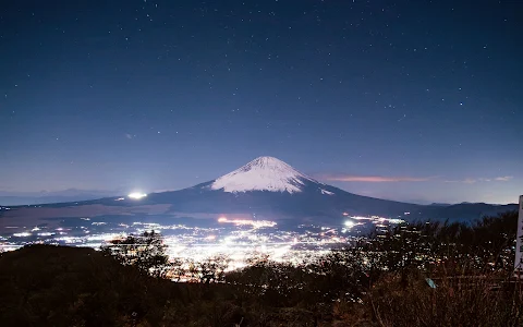
Mt.
Fuji,
located
26.28
km
(16.33
mi)
northwest
from
peak
of
Kintokiyama.
3 people found this review helpful 👍