5/5 Aljadeed 3 years ago on Google
Outstanding
view.
Awesome
area.
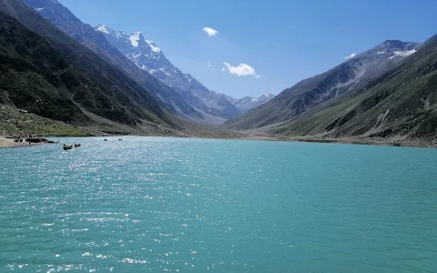
Saiful
Muluk
is
a
mountainous
lake
located
at
the
northern
end
of
the
Kaghan
Valley,
near
the
town
of
Naran
in
the
Saiful
Muluk
National
Park.
At
an
elevation
of
3,224
m
(10,578
feet)
above
sea
level,
the
lake
is
located
above
the
tree
line,
and
is
one
of
the
highest
lakes
in
Pakistan.
Saiful
Muluk
is
located
in
the
Mansehra
district
of
Khyber
Pakhtunkhwa,
about
9
kilometres
(5.6
mi)
north
of
Naran,
in
the
northern
part
of
Kaghan
Valley.
Malika
Parbat,
the
highest
peak
in
the
valley
is
near
the
lake.
The
lake
is
accessible
from
the
nearby
town
of
Naran
during
the
summer
season
but
access
during
winter
is
limited,
as
heavy
snowfall
and
landslides
threaten
to
cutoff
the
lake
from
other
regions.
Saiful
Muluk
was
formed
by
glacial
moraines
that
blocked
the
water
of
the
stream
passing
through
the
valley.
The
Kaghan
Valley
was
formed
in
the
greater
Pleistocene
Period
dating
back
almost
300,000
years
when
the
area
was
covered
with
ice.
Rising
temperatures
and
receding
glaciers
left
a
large
depression
where
glaciers
once
stood.
Melting
water
collected
into
the
lake.
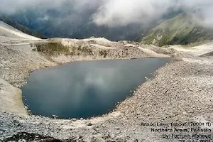
The
lake
has
rich
eco-diversity
and
holds
many
species
of
blue-green
algae.
Large
brown
trout
are
found
in
the
lake,
up
to
about
seven
kilograms.
About
26
species
of
vascular
plant
exist
in
the
area,
with
Asteraceae
the
most
commonly
found
species.
Other
species
commonly
found
in
the
region
are:
Ranunculaceae,
Compositae,
Cruciferae,
Gramineae,
Apiaceae,
Leguminosae,
Scrophulariaceae
and
Polygonaceae.
The
Lake
Saiful
Muluk
is
named
after
a
legendary
prince.
A
fairy
tale
called
Saif-ul-Muluk,
written
by
the
Sufi
poet
Mian
Muhammad
Bakhsh,
talks
of
the
lake.
It
tells
the
story
of
the
prince
of
Persia
named
Prince
Saiful
Malook
who
fell
in
love
with
a
fairy
princess
named
Princess
Badri-ul-Jamala
at
the
lake.
👉Location
Saiful
Muluk
National
Park
Kaghan
Valley
Coordinates
34.876957°N
73.694485°E
Lake
type
Alpine,
glacial
lake
Primary
inflows
Glacial
water
Primary
outflows
Stream
(a
tributary
of
Kunhar
River)
Basin
countries
Pakistan
Surface
area
2.75
km2
(1.06
sq
mi)
Max.
depth
113
ft
(34
m)
Surface
elevation
3,224
metres
(10,577
ft)[1]
Settlements
Naran
8 people found this review helpful 👍