4/5 Tahir S. 1 year ago on Google
Badgoi
Pass
has
122
review
so
far
it
means
very
few
people
reach
there
during
season.
It's
remains
close
in
summer
rainy
season
and
winter
snowfall.
Best
month
to
visit
is
june.
This
road
is
impassable
from
October
to
May.
Check
weather
forecast
before
traveling
if
you
found
40%
rain
possiblity
wait
for
below
20
%
as
this
road
is
deadliest
in
the
region
and
one
of
the
dangerous
road
in
the
world.
Only
4x4
jeep
with
high
clearance,
brave
and
skilled
driver
is
recommended.
Stay
away
if
you
have
hight
phobia.
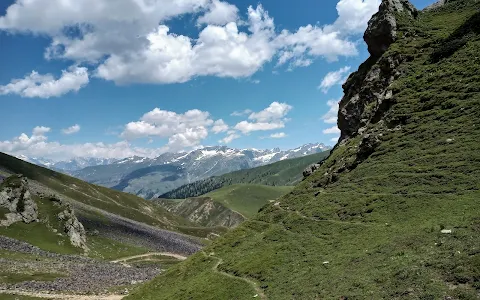
Badgoi
top
at
elevation
of
11,558ft
is
the
hill
top
on
the
road
connecting
Thal
Valley
to
Kalam.
Distance
from
Thal
Valley
is
20
km
Upward
and
from
village
Utror
,
Kalam
side
it's
12
km
steep
slops
and
sharp
turns
upward.
The
most
dangerous
part
is
12
km
downward
towards
Utror.
Total
distance
of
the
Utror
Dir
road
is
32
km
from
Thal
Valley
Kumrat
side
to
Utror
village
Kalam
side.
Local
rental
jeep
drivers
will
estimate
your
time
around
2/3
hours
but
average
speed
of
4WD
is
5-7
km/
hour.
It
will
take
more
than
5
hours
to
pass
this
32
km
mountain
range
with
beautiful
scenic
snowy
peaks,
moderate
breeze,
cold
weather
and
breathtaking
landscape.
I'll
recommend
tourist
bike
with
supporting
accessories
rather
than
4x4.
No
gas
station,
No
tire
shop
on
the
way.
Basic
food/
drinks
with
⛺
tent
accommodation
is
available
on
Badgoi
Pass.
Dasht-e-Laila
peak
is
visible
from
this
place.
Join
"Islamabad
Hiking
Trails"
group
on
facebook
for
more
reviews
and
tourism
updates.
#islamabadhikingtrails
#islamabadianz
#hiking
#hikingadventure
#tourism
#kalam
#thal
#kumrat
10 people found this review helpful 👍