5/5 Donna B. 6 months ago on Google • 90 reviews
This
was
my
third
hike
to
Mushroom
Rock,
and
each
time
I
turned
the
corner
and
saw
the
massive
mushroom-shaped
rock,
I
was
in
awe.
The
hike
via
Shackleford
Park
Trail
is
easy,
but
unless
you
are
up
for
a
much
longer
hike
with
more
elevation
change,
make
sure
you
go
to
the
trailhead
at
2650
Sam
Powell
Drive.
The
parking
is
behind
a
school
next
to
the
soccer
field.
From
the
parking
lot,
go
down
the
steps
to
a
Kiosk.
The
map
on
the
Kiosk
is
for
the
Cumberland
Trail
and
the
Blue
Loop,
so
it
may
be
confusing
if
you
just
want
to
go
to
Mushroom
Rock.
Facing
the
Kiosk,
take
your
trail
on
the
left
(do
not
go
over
the
suspension
bridge
).
When
you
reach
the
first
fork,
turn
right
(there
will
be
a
stump
with
a
blue
slash
on
it
at
this
fork).
Stay
on
the
trail;
the
next
two
turns
will
have
cute
wooden
signs
with
blue
type
pointing
the
way.
The
main
things
to
watch
out
for
on
the
trail
are
roots
and
rocks,
so
you
may
want
your
walking
sticks.
One
part
of
the
trail
was
a
little
wet
when
we
were
there,
but
it
was
certainly
passable.
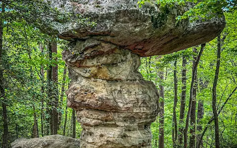
Mushroom
Rock
is
located
in
a
small
opening
in
the
woods
near
a
steep
slope.
Be
sure
to
look
at
it
from
all
sides,
as
it
is
fascinating.
Mushroom
rocks,
or
the
less
fun
name,
Rock
Pedestals,
are
found
worldwide.
Many
are
formed
by
wind
or
water
eroding
the
bottom
part
of
the
rock
faster
than
the
top.
Others
are
formed
by
glacial
action,
where
a
larger
rock
comes
to
rest
on
another
rock.
The
lower
rock
may
also
have
eroded
to
accentuate
the
mushroom
shape.
I
believe
Mushroom
Rock
in
Signal
Mountain
is
one
of
the
latter.
(see
photos)
When
you
leave
Mushroom
Rock,
take
the
same
trail
you
came
in
on.
On
the
return,
you
will
go
uphill
for
a
short
while,
but
the
elevation
change
is
minimal.
If
you
are
up
for
a
longer
hike,
there
are
many
options,
including
the
Blue
Loop
Trail
on
the
other
side
of
the
suspension
bridge.
8 people found this review helpful 👍