Featured Reviews


Frequently mentioned in reviews: Bangladesh (21) Keokradong (14) peak (10) highest (10) point (6)
Reviews are sorted by relevance, prioritizing the most helpful and insightful feedback at the top for easier reference.
  • 5/5 Tahsina Naz K. 2 years ago on Google
    The 'Keokradong' peak of Bandarban is a beautiful place to visit. One can go there by both trekking and transport (especially, a local high-capacity engine operated zeep called 'chander gari' (car of moon). Very steep and zigzag roads will lead you to the peak. There are local tin-shed cottages like 'mountain view' on the peak for tourists, restaurants, an army camp, a helipad, etc. A battery-operated torch light is very useful at night because the washroom is somewhat in distant from the cottage. Never miss the views of sunrise and sunset especially from the helipad. The street dogs of Keokradong are very special - they are friendly and protective! We also found a friendly goat kid, a cat, and a pet eagle. There are also some pet cows. One day and one night of staying is enough. You must visit Keokradong to get a different taste in life!
    12 people found this review helpful 👍

  • 5/5 Pritom 2 years ago on Google
    Some sources claim Keokradong (3235 feet) as the highest point of Bangladesh.But "Tazing Dong" is officially recognized as the highest point of Bangladesh. Also there is a controversy that "Saka Haphong" is the most elevated peak of the country.But it is not official. Among of all the peaks Keokradong is the center of attraction for travelers and trekkers. Because there one can get the facilities for staying. If anyone wants to spend a night with clouds around him surely Keokradong is the best choice for him.
    8 people found this review helpful 👍

  • 5/5 Syed Jahid H. 1 year ago on Google
    Keokradong is the fifth highest mountain in Bangladesh. Keokradong has an elevation of 3172 feet. At one time it was the highest mountain in Bangladesh.
    2 people found this review helpful 👍

  • 5/5 Rusho R M. 1 year ago on Google
    KeoKradong is one of the tourist attraction place at Banderban. KeoKaradong Height in meter - 986 meter (3225ft). The place is beautiful for the nature and his weather changing within a seconds. Also, we are the first garo peoples group summit on date 11-07-2022. We aren’t able to take a shot of our group photo cause of the weather.
    1 person found this review helpful 👍

  • 5/5 Asadullah T. 2 years ago on Google
    Best place n people I have ever seen❣️❣️
    1 person found this review helpful 👍

  • 5/5 S.M. R. 2 years ago on Google
    One of the best place for visit. Hope your all effort will not go in vain. It's not a place for weak person. Please avoid if you are not physically strong. Need mentally and physically strong person to visit. Best view you will get. Also follow army rules. You will get guide from Ruma bazar. Car will come only Boga lake. Then you have to walk to reach the golden place. If anything you want to know ask questions.
    1 person found this review helpful 👍

  • 5/5 Nura J. 3 years ago on Google
    One of the most beautiful trekking route of Bangladesh... Really enjoyed the journey and the view from top of the mountain 🥰
    1 person found this review helpful 👍

  • 5/5 Md Younus H. 3 years ago on Google
    Keokradong is a peak located in Bandarban, Bangladesh, with an elevation of 986 metres. Some sources claim it as the highest point of Bangladesh. On the top of Keokradong there is a small shelter and a signboard put up by Bangladesh Army proclaiming the elevation to be 967 metres. (wikip)
    1 person found this review helpful 👍

  • 5/5 Tajul Islam K. 4 years ago on Google
    Its a place where you find your lost soul. Highest pick of Bangladesh. Hard to reached by 5 hours walking high hill. Sunrise was a great experience too. Its a worth place to have a unforgettable adventure in Bangladesh hill track
    1 person found this review helpful 👍

  • 5/5 Moniruzzaman T. 1 year ago on Google
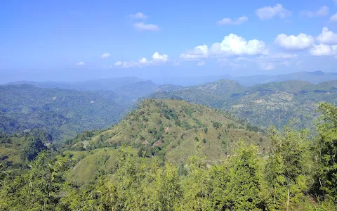
    Keokradong is a peak located in Bandarban, Bangladesh, with an elevation of 986 metres (3,235 ft).[2] Some sources claim it as the highest point of Bangladesh. On the top of Keokradong there is a small shelter and a signboard put up by Bangladesh Army proclaiming the elevation to be 967 metres (3,173 ft). Height measured by handheld GPS shows it is 986 metres (3,235 ft) with 3m accuracy.[3] There is a controversy about the highest point of Bangladesh, and some sources indicate Saka Haphong as the most elevated peak of the country.[4] However, Tazing Dong is officially recognized as the highest point of Bangladesh. Keokradong is a popular tourist attraction in Bangladesh for mountaineers.[5] Keokradong is one of the cloudiest places in Bangladesh.

  • 4/5 Rokon A. 2 years ago on Google
    Awsom place for natural beauty but weather is too cold at night.

  • 5/5 Sakhawat H. 1 year ago on Google
    Mount Keokradong (1230 Merers) is located in the Ruma thana of Bandarban district. It is roughly 4-5 hours of walk from Boga lake. It is absolute peace once you're up there. The trail up to the peak can be sometimes challenging due to high proneness of leeches. Worth spending a night on the tent and see both the sunset and sunrise. Previously it was considered as one the highest peek in Bangladesh but now the place is taken by another one.

  • 5/5 Shibly S. 1 year ago on Google
    Higest Peak Of Bangladesh 3172 Feet

  • 5/5 Mohd S. Taneem (. 1 year ago on Google
    Officially 2nd largest peak in Bangladesh. Situated in Ruma Bazar, Bandarban.

  • 4/5 Md. R. 1 year ago on Google
    Specially the distance between kreokradong and darjiling para is amazing to watch for trekkers. Also kreokradong peak is very beautiful.

  • 4/5 Afnan H. 4 years ago on Google
    This place is amazing if you think of the view of surroundings. If the sky is clean and there is no cloud around, you can see the unofficially highest pick of Bangladesh, Saka Hafong, from here. Recently they have started to build VIP cottage. However, the cost of living and food is pretty high here.


Open on Google Maps

Trends


Last updated:

Similar Peaks nearby

Last updated:
()