5/5 Taner I. 3 years ago on Google
(Translated
by
Google)
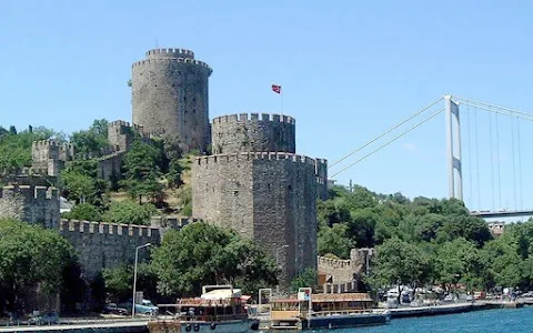
Anadolu
Hisar
(Also
Known
As
Güzelce
Fortress)
is
located
in
the
Anatolian
Fortress
District
of
Istanbul,
where
the
Göksu
Stream
flows
into
the
Bosphorus.
Anadolu
Hisarı
was
built
on
an
area
of
7000
square
meters,
on
the
narrowest
point
of
the
Bosphorus,
at
a
distance
of
660
meters,
in
1336
by
Yıldırım
Beyazıt.
The
Genoese
Unified
with
Byzantium
and
Established
Colonies
in
the
Black
Sea
(Kefe,
Sinop
and
Amasra).
For
this
reason,
the
Bosphorus
Crossing
was
of
vital
importance
for
the
Genoese.
The
same
situation
was
also
in
question
for
the
Ottomans.
The
Rumeli
Fortress,
Located
on
the
European
Side
of
Istanbul,
on
the
opposite
shore,
was
built
between
1451-1452
by
Mehmet
the
2nd,
in
order
to
keep
the
passage
of
the
ships
of
these
foreign
countries
under
control.
While
Sultan
Mehmed
the
Conqueror
Constructed
the
Rumeli
Fortress,
he
added
outer
walls
to
this
castle.
It
consists
of
the
Anatolian
Castle,
the
Inner
and
the
Outer
Castle
and
the
Walls
of
These
Castles.
The
Inner
Castle
is
a
Rectangular
Four-Storey
Tower.
When
it
was
first
built,
because
there
was
no
entrance
door,
the
tower
was
entered
through
a
suspension
bridge
extending
to
the
inner
castle
walls.
The
upper
floors
were
also
reached
by
the
wooden
stairs
inside.
The
Inner
Fortress
Walls
Join
the
Northeast
and
Northwest
Corners
of
the
Outer
Fortress.
These
Walls
Are
Three
Meters
Thick.
Above
the
Outer
Fortress
Walls
Combining
with
the
Inner
Walls,
There
are
Many
Arches
and
the
Inner
Tower
Built
to
Protect
the
Walls.
The
Walls
of
the
Main
Castle
are
65
meters
in
the
East-West
Direction;
Extends
80
meters
in
the
North-South
Direction.
The
thickness
of
the
walls
is
2.5
meters.
On
the
outer
walls,
there
are
culverts
where
balls
are
placed.
Block
stones
filled
with
mortar
were
used
in
the
main
castle
and
walls
of
the
Anatolian
Fortress.
After
the
conquest
of
Istanbul,
the
Anatolian
Fortress
lost
its
military
importance
and
its
surroundings
became
a
settlement
area
in
time.
A
road
passes
through
the
middle
of
the
Anatolian
Fortress,
some
parts
of
which
are
destroyed
today.
(Original)
Anadolu
Hisar
(Güzelce
Hisarı
Olarak
da
Bilinir),
İstanbul’un
Anadolu
Hisarı
Semtinde,
Göksu
Deresi’nin
İstanbul
Boğazı’na
Döküldüğü
Yerdedir.
Anadolu
Hisarı,
7000
Metrekarelik
Bir
Alan
Üzerine,
Boğazın
En
Dar
Noktası
Olan
660
Metre
Mesafedeki
Bölgesine
1336
Yılında,
Yıldırım
Beyazıt
Tarafından
İnşa
Edilmiştir.
Cenevizliler,
Bizans’la
Birlik
Olup
Karadeniz’de
(Kefe,
Sinop
Ve
Amasra’d)
Koloniler
Kurmuşlardı
Bu
Sebeple,
Boğaz
Geçişi
Cenevizliler
İçin
Hayati
Önem
Taşımaktaydı.
Aynı
Durum
Osmanlılar
İçin
de
Söz
Konusuydu.
Karşı
Sahilde,
İstanbul’un
Avrupa
Yakasında
Bulunan
Rumeli
Hisarı
İse,
1451-1452
Yılları
Arasında
2.
Mehmet
Tarafından,
Bu
Yabancı
Ülkelerin
Gemilerinin
Geçişlerini
Denetim
Altında
Tutabilmek
Amacıyla
İnşa
Ettirilmiştir.
Fatih
Sultan
Mehmed,
Rumeli
Hisarı’nı
Yaptırırken
Bu
Kaleye
Dış
Surlar
Ekletmiştir.
Anadolu
Hisarı,
İç
Ve
Dış
Kale
İle
Bu
Kalelerin
Surlarından
Oluşur.
İç
Kale,
Dikdörtgen
Biçimindeki
Dört
Katlı
Bir
Kuledir.
İlk
Yapıldığında,
Bir
Giriş
Kapısı
Bulunmadığı
İçin,
Kuleye
İç
Kale
Surlarına
Uzanan
Bir
Asma
Köprüden
Giriliyordu.
Üst
Katlarına
da
İçerideki
Ahşap
Merdivenlerle
Çıkılıyordu.
İç
Kale
Surları,
Dış
Kalenin
Kuzeydoğu
Ve
Kuzeybatı
Köşelerini
Birleştirir.
Bu
Surlar
Üç
Metre
Kalınlığındadır.
İç
Surlarla
Birleşen
Dış
Kale
Surlarının
Üzerinde
Birçok
Kemer
Ve
Surları
Korumak
İçin
Yapılmış
İç
Kule
Bulunur.
Asıl
Kalenin
Surları
Doğu-Batı
Yönünde
65
Metre;
Kuzey-Güney
Yönünde
80
Metre
Boyunca
Uzanır.
Surların
Kalınlığı
2.5
Metredir.
Dış
Surlarda
Topların
Yerleştirildiği
Menfezler
Bulunur.
Anadolu
Hisarı’nın
Asıl
Kaleninde
Ve
Surlarında,
Araları
Harçla
Doldurulmuş
Blok
Taşlar
Kullanılmıştır.
Anadolu
Hisarı
İstanbul’un
Fethinden
Sonra
Askeri
Önemini
Yitirmiş,
Çevresi
Zamanla
Bir
Yerleşim
Bölgesi
Durumuna
Gelmiştir.
Bugün
Bazı
Bölümleri
Yıkık
Olan
Anadolu
Hisarı’nın
Ortasından
Yol
Geçmektedir.